‘Scene V’ was a beat music group in the early 1960s with, from Mitcham, drummer Stuart Hall from Birch Walk, Colin Taylor, Brenley Close and Steve Brown, Woodstock Way. They had all met at Lonesome Primary School, and afterwards had gone to Rowan Road School.
Also in the band were singer from Battersea, Graham (Eddie) Cheriton, and rhythm guitarist and songwriter Paul Williams, from Tooting.
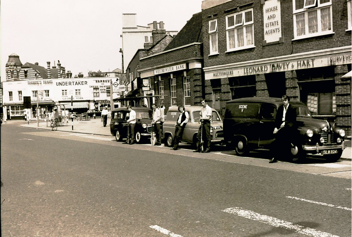
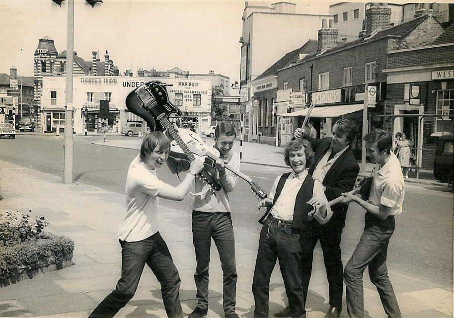
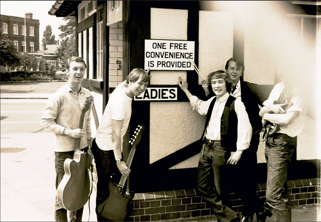
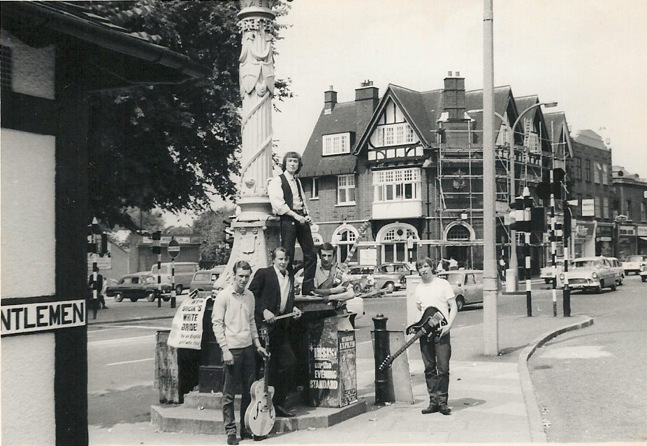
These publicity photos were posted to the Mitcham History Group on Facebook in 2014 by Stuart Hall. They are believed to have been taken in 1964.
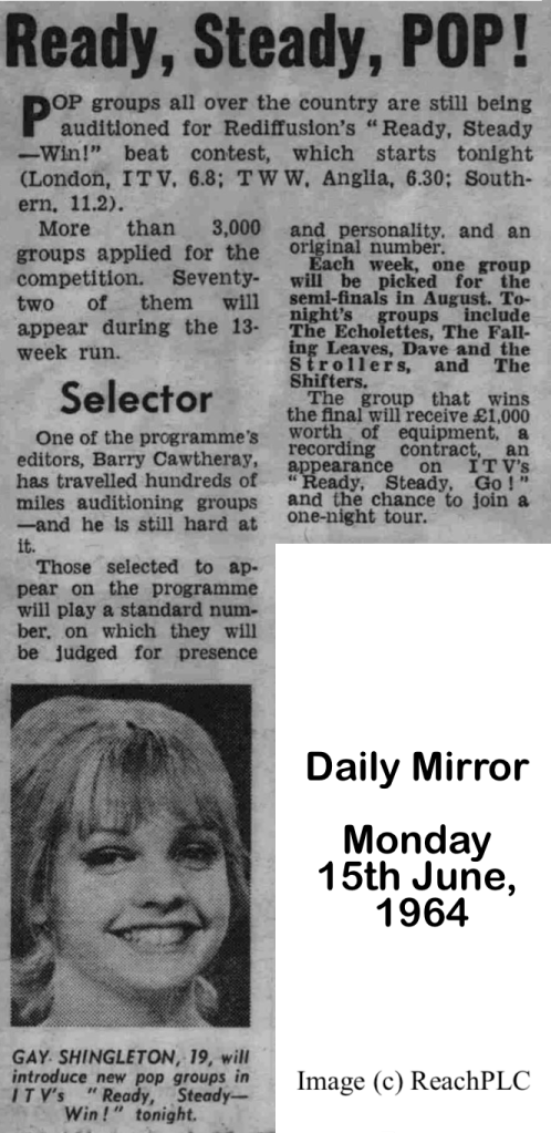
The band appeared on the ITV show “Ready, Steady, Win!”, which was made by the same production team as “Ready, Steady, Go!”. It was a beat contest that drew submissions across the country by over 3,000 groups. The prizes for the winner were one thousand pound’s worth of equipment, a possible recording contract, and an appearance on “Ready, Steady, Go!”
“Ready, Steady, Win!” was shown on Monday evenings, just after the 6pm news, and ran over three months from June to August. Each programme had 6 bands, the winner of each being placed in the semi-finals. The first programme featured The Echolettes, The Falling Leaves, Dave and the strollers, and The Shifters.
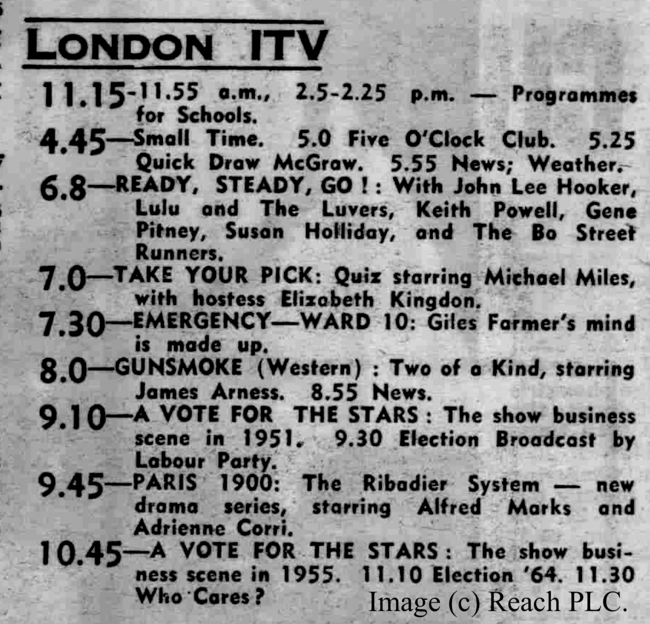
The final winner was The Bo Street Runners. They appeared on the “Ready, Steady, Go!” show on Friday 2nd October 1964, as shown in this television listing from the Daily Mirror.
Paul Williams wrote about appearing on the Ready, Steady, Win! show in a post on the Mitcham History Facebook group on 9th July 2024:
We did the audition a few weeks earlier at the Ready Steady Go studios in Kingsway, which was awesome because of all the big names we knew had played in there. The actual show was recorded at the Wembley Park studios which was also amazing. Lots of other programs were being recorded, and at first we thought there had been some sort of incident because there were police walking about, and then soldiers with blood all over them. It turned out they were making Lockhart with Raymond Huntley. He came into the studio while we were rehearsing and was a lovely bloke. Very chatty and informal.
The thing that struck me about the show itself was the sound balancing, or rather the lack of it! Some bloke came on our small stage, there were three in all to accomodate six bands, and moved our amps into a triangular pattern. Then he stuck a mike in the middle, listened to someone via headphones, asked us to play a few bars of ‘Anytime’, then moved one amp closer to the mike before going away! That was their idea of balancing. Also Eddie and I had no monitors for the vocals so we didn’t know if we were too loud or how much E.Q. there was. The final sound of the instruments in the studio sounded okay but we couldn’t judge the vocals. Consequently when the show went out six days later I was actually ashamed of how bad it sounded. It was very bassy and distorted.
Regarding ‘Anytime’ we had to record it twice at R.G. Jones’s old studio because Decca didn’t like my lyrics. Originally, and to make it more original, I wrote it about a man losing his wife and talking to his kids to come and visit him. They somehow thought that was in bad taste and unacceptable. How times have changed.
Their song, Anytime, can be heard on this video on YouTube. Turn on subtitles to see the lyrics.
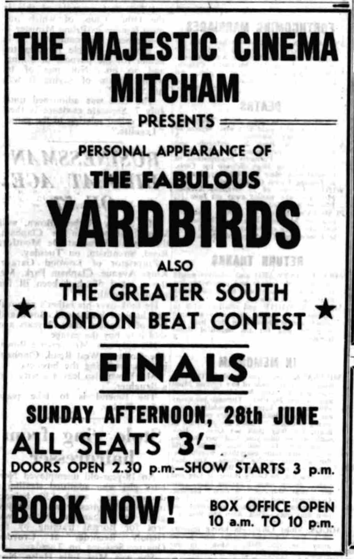
On Sunday 28th June 1964, they appeared at the Majestic cinema in Mitcham in ‘The Greater South London Beat Contest’.
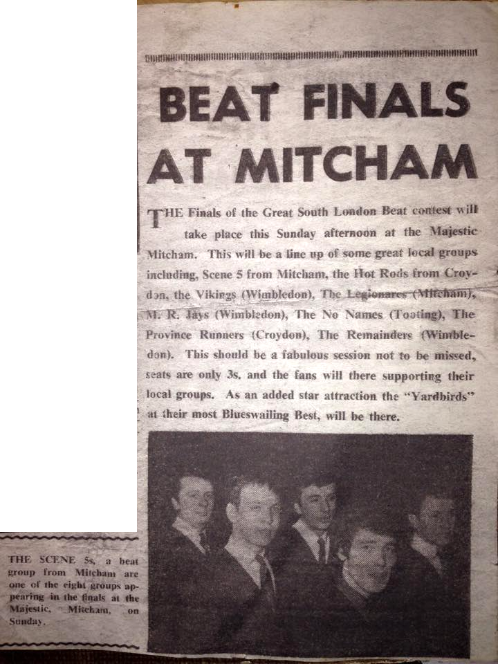
The Finals of the Great South London Beat contest will take place this Sunday afternoon at the Majestic Mitcham. This will be a line up of some great local groups including, Scene 5 from Mitcham, the Hot Rods from Croydon, the Vikings (Wimbledon), The Legionares (Mitcham), M. R. Jays (Wimbledon), The No Names (Tooting), The Province Runners (Croydon), The Remainders (Wimble-don). This should be a fabulous session not to be missed, seats are only 3s. and the fans will be there supporting their local groups. As an added star attraction the “Yardbirds” at their most Blueswailing Best, will be there.
Streatham News, 26th June 1964
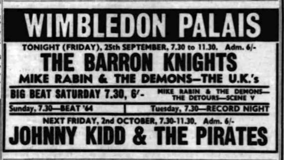
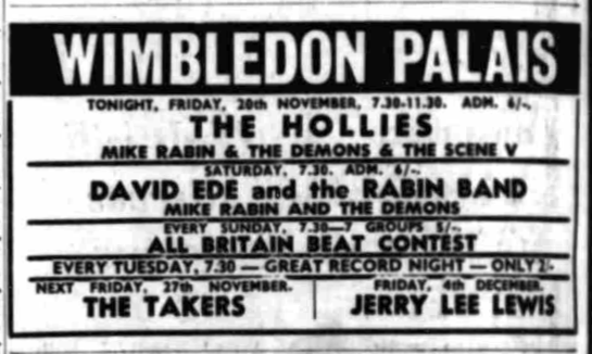
The band also appeared at the Wimbledon Palais on the Big Beat Saturday of 26th September, and on Friday 20th November 1964.
Notes:
1. I couldn’t find when Scene V appeared on the Ready, Steady, Win! show. The artists were only listed in the Daily Mirror for the first and final programmes. Below is a chronological list of the judges that appeared. Perhaps it will jog someone’s memory!
15th June 1964
First round of New Beat Group Contest introduced by Keith Fordyce with Gay Shingleton, Michael Aldred.
Judges include Susan Maughan, Gerry Marsden and Norrie Paramor.
22nd June 1964
Judges Patsy and Noble, Lionel Bart, Mark Winter.
Introduced by Keith Fordyce.
29th June 1964
Judges Maureen Cleave, Adam Faith and Cyril Ornadel.
July 6th 1964
ITV programs are printed on the off chance that the present strike will be over.
No details given.
July 13th 1964
Judges Annie Ross, Chris Curtis and Tony Meehan.
20th July 1964
Judges Annie Ross, Chris Curtis and Tony Meehan.
Compere Keith Fordyce.
27th July 1964
Compere Keith Fordyce.
3rd August 1964
Judges include Elkie Brooks, Kenny Lynch and Dick Rose.
Compere Keith Fordyce.
10th August 1964
Judges Julie Grant, Long John Baldry, Tony Hatch.
17th August 1964
Judges Helen Shapiro, Alan Freeman, Manfred Mann.
24th August 1964
Judges Mick Jagger, Lulu and Alan Freeman.
31st August 1964
Judges Brenda Lee, Jack Baverstock, Robert Bickford and Eric Burdon.
7th September 1964
Judges Unity, John Burgess,
Tony Hall and Brian Paul.
This was the second semi-final.
Five groups will be competing each bringing along 50 supporters. “Seeing familiar faces around them seems to help the groups relax and play better,” says Francis Hitching who, with Barry Cawtharay, edits the programme.
14th September 1964
In the same slot, Search for a Star. New contest to find a top of the bill girl, introduced by Keith Fordyce.
“Anytime” was included in an LP collection, produced by Micky Most, of songs from that show. See the website discog.com for the full list of tracks. This album was re-issued in 1987 and in 1992 on Compact Disk.
Paul Williams recalled the recording session for the LP:
The studio was entered via an underground ‘car park’ off Kingsway in central London.
With our equipment set up, the singer and I stood in front of a mike in the vocals booth ready to do the first take. Turning to him I whispered, ” I wonder if this is the studio where The Animals recorded House of the Rising Sun?”
“Yes it is!” A hidden voice spoke back to us through the monitors! Our mouths wide open we stared at each other before speaking again.
“Perhaps Lulu used this very mike to record Shout?”
“Yes she did!” The reply came back.
” — And the Nashville Teens?”
“Yes!”
“— Herman’s Hermits?”
“Them as well!”
