Pub that was at 222 High Street, Colliers Wood, Merton. Currently (2025) it is a restaurant.
Contents
Eric Montague Photos
Timeline
Newspaper articles
Maps
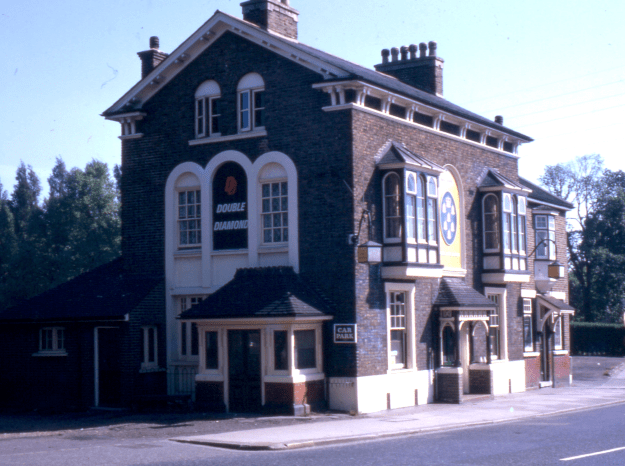
1966 photo by Eric Montague, reproduced by kind permission of the Merton Historical Society
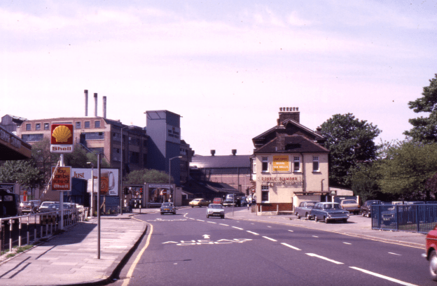
1974 photo by Eric Montague, reproduced by kind permission of the Merton Historical Society
I. ANCIENT FOUNDATIONS & EARLY ORIGINS
AD 43 – 400s | The Roman Road
- Context: The site lies on Stane Street (A24), the Roman arterial road connecting London to Chichester.
- Significance: This route established Merton as a focal point for transit for centuries to come.
Medieval Era | The Ecclesiastical Link
- Context: The name “Six Bells” almost certainly refers to the peal of bells at the nearby St. Mary’s Church, linking the pub to the parish’s auditory and religious identity.
II. THE COACHING INN ERA (1750 – 1854)
1750 (July) | The First “Six Bells”
- Event: Richard Hollamby insures a new building: “The Six Bells Alehouse, unfinished… at Merton Bridge”.
- Structure: A two-storey, weatherboarded timber structure with a pantiled roof.
c. 1800 | A Vital Stop
- Status: Recorded as a large public house in the possession of Mr. Newman.
- Function: Located near the “Single Gate” tollgate, it served as a mandatory stop for travelers moving between rural Surrey and London.
1833 (May) | Community Hub
- Event: Parish officers “beating the bounds” of Mitcham stop here for lunch, establishing it as a civic and social node.
III. THE VICTORIAN PUB & ROYAL PATRONAGE (1855 – 1994)
1855 | The Rebuild
- Event: The original wooden inn is demolished (likely for water main works).
- The current yellow stock brick building is erected in just three weeks by local builder James Bass to be ready for Derby Day.
Late 19th Century | The “Royal” Connection
- Event: Renamed The Royal Six Bells.
- Reason: The Prince of Wales (later King Edward VII) frequented the inn to change horses and rest while travelling to the Epsom Derby.
- Clientele: It served a dual purpose: a high-class stop for Derby travelers and a “third space” for local mill and textile workers.
1891 | The Local Fabric
- Context: Census records show the pub surrounded by a dense workforce living in cottages like “Barnes Cottages” opposite, emphasizing its role in the “industrious village”.
WWII (1939–1945) | Civil Defense
- Adaptation: The nearby Wandle Park swimming pool (behind the pub) is converted into a communal air-raid shelter, integrating the pub’s geography into local defense.
IV. IDENTITY CRISIS & DECLINE (1995 – 2007)
c. 1995 – 2000 | “Riverside”
- Rebrand: Name changed to Riverside to highlight proximity to the River Wandle.
c. 2000 – 2005 | “Baobab”
- Rebrand: Renamed Baobab, adopting a thematic/modern branding concept.
2005 – 2007 | “Blue”
- Rebrand: Renamed Blue, attempting a minimalist lounge/bar aesthetic to attract younger clientele.
V. CATASTROPHE & REBIRTH (2007 – Present)
2007 (July 1) | The Great Flood
- Event: Severe flooding of the River Wandle causes significant damage to the building.
- Outcome: The pub closes its doors and remains boarded up for several years, ending its life as a licensed public house.
2011 (September) | Delhi Heights
- Rebirth: The building is repurposed and opens as Delhi Heights, an Indian restaurant.
2015 – Present | Istanbul Meze Mangal
- Current Status: The site operates as Istanbul Meze Mangal, a Turkish restaurant.
- Legacy: The building remains on the Local List of Buildings of Historical or Architectural Interest, preserving the Victorian streetscape.
Newspaper Articles
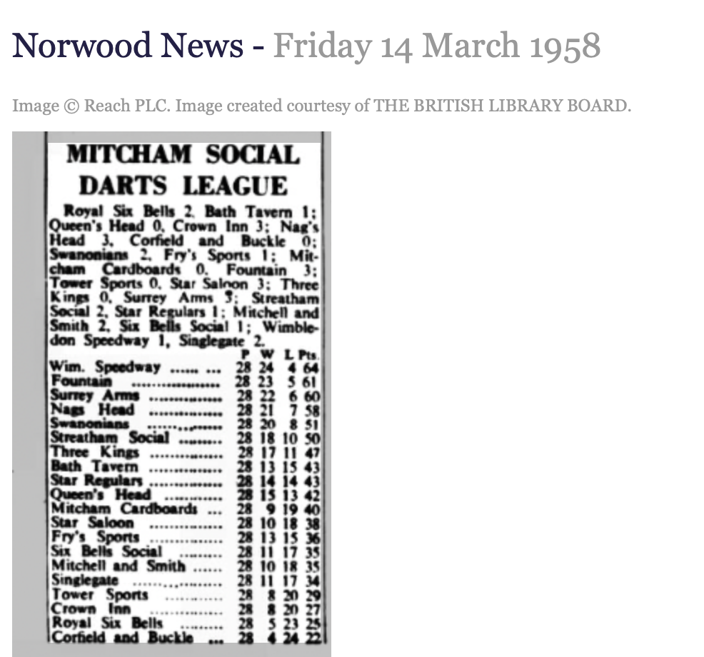
Norwood News – Friday 14 March 1958
Croydon Express – Saturday 17 December 1910
MERTON. A.O.D.—The Merton Abbey Lodge of the Ancient Order of Druids, which holds its meetings at the “Royal Six Bells,” High-street, Collier’s-wood, Merton, gave an “open night” at that hostelry on Friday last, and a large and representative company Of Druids and their friends attended, amongst others being members of the Wimbledon, Merton,and Mitcham Councils. Noble Arch Birch presided, and Vice Arch Owen occupied the position of vice chairman. A splendid pro gramme had been arranged under the direction of P.A. Reeves, and the harmony was continued till a late hour. During the evening P.A. Nawton. the Patriarch of the Lodge, gave a brief address on “Druidism and its objects—justice, philanthropy, and brotherly love.”
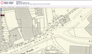
Ordnance Survey maps are reproduced by permission of the National Library of Scotland, reuse CC-BY.
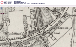
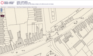
1865 OS map
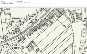
1894 OS map
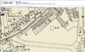
1911 OS map
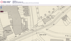
1934 OS map
1950 OS map
1966 OS map