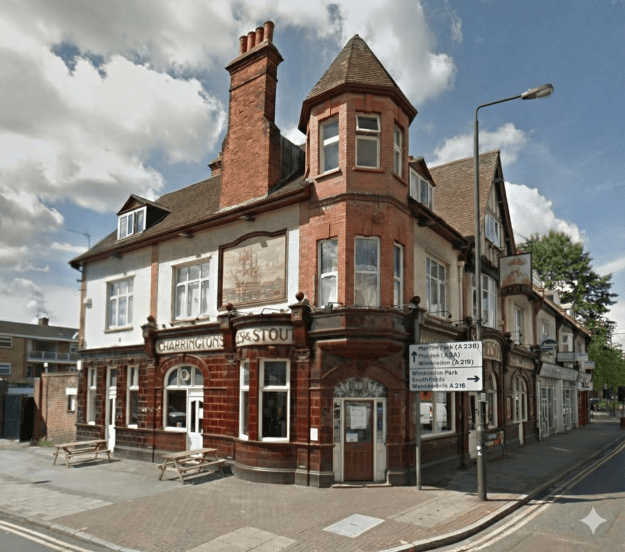
Pub at 198 High Street Colliers Wood, London SW19 2BH, now called The Holden.
Contents
Timeline
Maps
News articles
Licensees
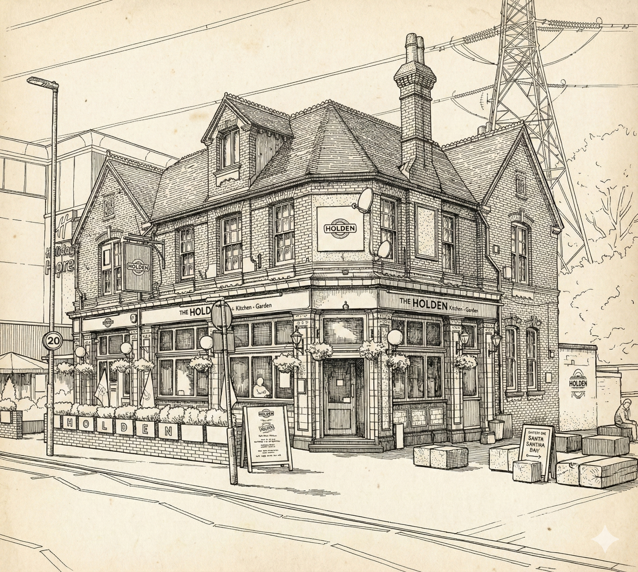
The Holden, from a Google Street View of May 2025
A Historical Timeline of The Victory Public House, Colliers Wood
Introduction: A Local Landmark Through Time
Situated at 198 High Street, the public house in Colliers Wood has stood as a significant local landmark for over a century and a half. This document traces the history and evolution of this enduring establishment, chronicling its journey from its mid-19th-century origins as ‘The Victory’ to its contemporary identity as ‘The Charles Holden’. The pub’s successive name changes serve as a mirror, reflecting the changing character of Colliers Wood itself. Its story is a microcosm of the area’s broader transformation, from a semi-rural hamlet known as ‘Singlegate’ to the bustling London suburb it is today.
1. Mid-19th Century Origins: The Birth of ‘The Victory’
In the mid-19th century, the location of a public house was a matter of strategic importance, determining its clientele and its role within the community. At this time, Colliers Wood was little more than a small village known as ‘Singlegate’, a cluster of dwellings huddled along the busy Merton turnpike road. It was in this context that ‘The Victory’ was established. Its position was deliberately chosen, located near the ‘Singlegate’ tollgate which, until its removal in 1870, controlled passage along the High Street for the ‘Epsom, Ewell, Tooting, Kingston upon Thames and Thames Ditton Turnpike Trust’.
The new pub would have served a dual purpose. It catered to the needs of the local population of the small hamlet, providing a vital social space. Simultaneously, it offered refreshment and rest to the steady stream of commercial traders and travelers navigating the turnpike road. This early identity, rooted in the rhythms of a semi-rural village and the flow of horse-drawn traffic, provided the foundation for an establishment that would witness and adapt to the profound changes on the horizon.
2. The Victorian & Edwardian Era: Becoming a Community Hub
The character and purpose of ‘The Victory’ were fundamentally reshaped by the rapid suburbanization of Colliers Wood in the late 19th and early 20th centuries. The primary catalyst for this growth was the arrival of the Wimbledon to Tooting railway loop in 1868, which connected the formerly quiet village to the expanding metropolis and drew in a new residential population. As the area grew, the pub evolved from a simple wayside inn into a crucial social anchor for the burgeoning community.
Compelling evidence of its central position in local life can be found in the memories of the period. An adjoining piece of land became affectionately known as the “Victory Field”, serving as a cherished play area for the neighbourhood’s children during the Edwardian era. This simple fact illustrates the pub’s deep integration into the fabric of the community. ‘The Victory’ operated amidst a vibrant local culture, witnessing the spectacle of visiting circuses like “Sanger’s” and “Colonel ‘Buffalo Bill’ Cody’s”, and the boisterous annual cavalcade of Londoners passing through on Derby Day. Social historians would note the particular colour of this event, where some Londoners, in high spirits, would adorn a horse’s forelegs with “a pair of ladies’ ‘bloomers’”. The pub was no longer just a stop on a major road, but the heart of a lively and growing London suburb.
3. The 20th Century: Witness to Modernization and Change
The 20th century heralded an era of intense modernization that irrevocably altered the landscape of Colliers Wood, and with it, the environment of ‘The Victory’. The 1920s were particularly transformative, with the construction of the landmark Underground station—on the former site of the old tollgate—and the adjacent bus garage. These developments solidified the area’s status as a key transport hub and brought a new wave of residents and commuters.
Throughout these decades, ‘The Victory’ would have adapted to serve a changing demographic. While specific records are scarce, its continued presence suggests it remained a community landmark through the profound upheavals of two World Wars and post-war reconstruction. During the Blitz, it would undoubtedly have served as a vital hub for a community under duress—a place of refuge from the nightly raids, a centre for sharing news, and a symbol of resilience. The pub also witnessed key shifts in local identity, including the gradual eclipse of the old name “Single Gate.” This shift in nomenclature, as historical records suggest, likely reflected a growing social distinction between the established hamlet and the new suburban estates being built around Christ Church. Standing as a constant in a world of relentless change, ‘The Victory’ was set for its own radical transformations in the century to come.
4. The 21st Century: An Era of Rebranding and Reinvention
The new millennium brought a trend of pub rebranding across London, as operators sought to attract new clientele and create modern identities for historic establishments. ‘The Victory’ was a prime example of this phenomenon, undergoing a series of dramatic reinventions that reflected both commercial strategy and a nod to local heritage.
4.1. The ‘Colliers Tup’ (2005 – 2013)
In 2005, the historic name ‘The Victory’ was retired, and the pub was rebranded as the ‘Colliers Tup’. The timing of this change was particularly noted by local historians, as it occurred in the bicentenary year of Nelson’s victory at Trafalgar. This loss of a historic name connected to a key moment in British history was regarded by many as a “sad change” and a break with the area’s long-standing heritage.
4.2. ‘The Charles Holden’ (2013 – Present)
In April 2013, the pub underwent another, more historically resonant, transformation. It was renamed ‘The Charles Holden’, a direct tribute to the celebrated architect who designed the iconic, Grade II listed Colliers Wood tube station located directly opposite. This rebranding sought to ground the pub’s identity in the unique architectural heritage of its immediate surroundings. The interior and exterior were updated to reflect a modern, welcoming establishment.
Key Features of The Charles Holden:
- Ambiance: A light and airy interior.
- Layout: A flexible space offering a dining area, bar stool seating, and comfortable sofas.
- Decor: The pub features freezes depicting Charles Holden and displays paintings by local artists.
- Amenities: A large garden at the rear includes a bottled beer bar and a heated marquee.
- Exterior: The original tiling at the front of the building has been carefully restored, preserving a tangible link to its past.
The pub’s modern operational structure reflects its place within a larger corporate portfolio, even as its name celebrates a local icon.
| Detail | Information |
|---|---|
| Operator (from 2017) | Laine Pub Company |
| Previous Operator | New Pub Co (ex Massive) |
| Freehold Owner | Heineken UK |
This new identity represents a fusion of contemporary pub culture with a deep appreciation for the architectural history that defines Colliers Wood’s 20th-century character.
Conclusion: A Legacy of Adaptation
The journey of the public house at 198 High Street is a compelling narrative of adaptation. From its 19th-century origins as ‘The Victory’, a wayside inn serving travelers at the Singlegate tollgate, it evolved into a beloved community hub and, ultimately, into the modern, architect-themed establishment, ‘The Charles Holden’.
The pub’s history and its multiple identities offer a unique lens through which to view the social, cultural, and economic evolution of Colliers Wood. Each name change, from the patriotic ‘Victory’ to the modern ‘Colliers Tup’ and the heritage-conscious ‘Charles Holden’, marks a distinct chapter in the area’s story. It stands today as a resilient and adaptive local landmark, a testament to the idea that to endure, an institution must be willing to reinvent itself while remaining a constant and welcoming fixture on the High Street.
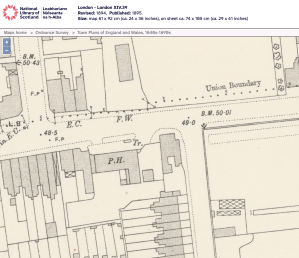
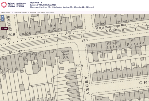
Maps
Ordnance Survey maps are reproduced by permission of the National Library of Scotland, reuse CC-BY.
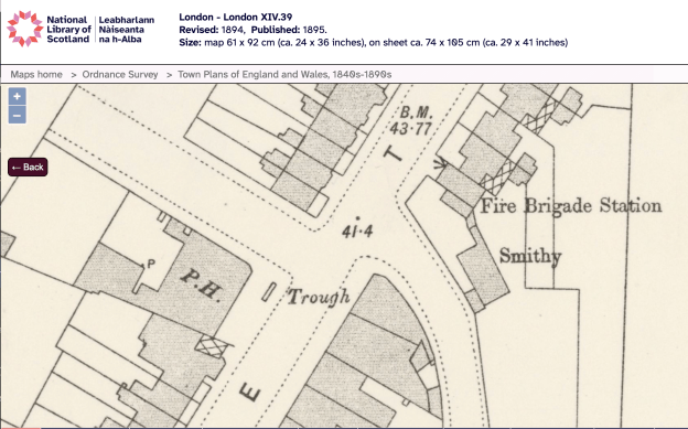
1894 OS map
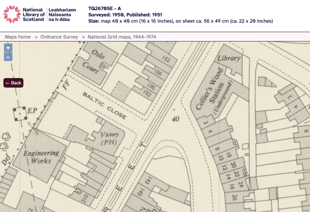
1950 OS map
Newspaper articles
The Sportsman – Saturday 31 October 1868
THE VICTORY INN, MERTON, SURREY.
The fine weather of Tuesday last caused a large number of the lovers of the trigger to assemble here to witness a match between two cracks, who had signed articles to shoot for a “tenner” a-side, at fifteen birds each, from H and T traps, 21 yards rise, the use of one barrel only and 1¼ oz shot, and the usual boundary. The sport took place in a meadow adjoining the hostelry, and a more level ground or one better adapted for the purpose could hardly have been selected.
A referee having been chosen in the person of a well-known member of the fourth estate, Mr Bowler won the toss, and elected to commence, slight odds being laid on Mr Short, and accepted by the partisans of his opponent. The first bird escaped, but Mr Short grassed his, and at the end of five was two to the good. He killed two out of his next five, and became three ahead, and eventually won at the eleventh round by scoring six to his opponent’s two.
Another match then took place between Mr Croucher and Mr Robinson, for 2l. a-side, same rise, &c., eleven birds each. Mr Croucher met with liberal support from a host of friends, and justified the confidence reposed in him by “walking away” from his opponent, and scoring seven birds out of ten, Mr Robinson only booking three out of nine.
Mr James then tackled Mr Robinson for a fiver, at fifteen birds each, same rise, fall, &c. Mr Robinson again came off second best, Mr James killing eleven out of fourteen to his opponent’s nine.
A half-sov sweepstakes followed by three members at five birds each, when Mr Croucher won at the fourth round, by dropping three out of his number. A “grunter” was then put up to be competed for by twelve members at 5s. each, five birds each, from H and T traps, &c. Mr Croucher and Mr Rouse killed four each, and agreed to divide.
Mr Franks at his fourth shot brought down his bird, but on the boy going to gather it it flew away, and not feeling satisfied with the referee’s decision, Mr Franks declined to take further part in the proceedings. A smaller pig was next put up, six members competing at five birds each. Mr Short and Mr Rouse killed three each, and agreed to divide. Several impromptu matches afterwards took place, and upwards of twenty-five dozen of Shrimpton’s birds were disposed of. Score:
MATCH, for 10l. a-side : fifteen birds each.
Mr Short ……………….. 1 0 1 0 1 1 0 0 1 0 1 —6
Mr Bowler……………….. 0 0 0 1 0 0 0 0 0 1 0 0—2MATCH, for 4l. ; eleven birds each.
Mr Croucher……………….. 1 0 0 1 1 0 1 1 1 1 —7
Mr Robinson ………………. 0 0 0 0 1 1 1 0 1 —3MATCH, for 5l. ; fifteen birds each.
Mr James …… 1 1 1 1 0 1 1 1 0 1 1 0 1 1 —11
Mr Robinson … 0 0 1 0 1 1 0 1 0 1 1 1 0 1 1—9SWEEPSTAKE of 10s. each.—Mr Croucher, 0 1 1 1; Mr Robinson, 1 0 0 0; Mr Short, 0 0 0.
SWEEPSTAKE for a fat pig.—Mr Croucher, 1 1 1 0 1; Mr Rouse, 0 1 1 1 1; Mr Short, 1 0 1 1 0; Mr Robinson, 0 0 1; Mr James, 1 1 0 0; Mr H., 0 0; Mr Scott, 0 0; Mr Charles, 0 1 0; Mr Storer, 0 0 0; Mr Eagles, 0 1 1 0 0; Mr Franks, 1 1 1 0, disq.
SECOND SWEEPSTAKE, for a fat pig.—Mr Short, 1 1 1 0 0; Mr Rouse, 0 1 1 0 1; Mr Robinson, 0 0 1 1 0; Mr Franks, 1 0 1 0 0; Mr Croucher, 0 1 0 0; Mr James, 0 0 0.
Wimbledon News – Saturday 07 August 1915
SCENES AT A COLLIER’S WOOD PUBLIC HOUSE.
The “Victory” Inn, High-street, Collier’s Wood, was the scene of some lively proceedings on Bank Holiday, which resulted in the appearance before the Croydon County magistrates on Tuesday of Frederick Nunn, aged 38, who was in khaki, on charges of breaking a plate-glass panel, value 30s., with assaulting John C. Ball, the licensee, and assaulting Leonard Boniface, the barman.
— John C. Ball, giving evidence, said prisoner had been “barred” from the house for three years on account of his conduct. On Monday night he entered under the influence of drink, began to argue with another man and a fight ensued. With the assistance of the barman witness ejected him. Prisoner made a series of rushes to get back into the house and in the course of the struggle took the barman by the arms and threw him through the heavy glass panel of the door.
— Dr. Mason, of Colliers Wood, said the barman had to have three stitches in his shoulder, there being an incised wound two inches long. Mr. Ball had a slight wound on the inside of his right cheek.
— Prisoner who said if he were let off it would never occur again, was remanded until Thursday.
— At Thursday’s hearing no further evidence was called.
— Prisoner said he thought the prosecution was trying to make a mountain out of a mole-hill.
— He was sentenced to two months’ imprisonment.
Norwood News – Friday 24 February 1961
Licensee dies Mr Waker Bradley, licensee of the Victory public house, Colliers Wood High Street, died recently. He was 57. Mr. Bradley. one-time Wandsworth Council chief clerk of works, had been at the Victory six years. He leaves a wife. two sons and a daughter. The funeral was on Wednesday.
Other than those noted, all licensees named below are from the “Pubs of Sutton and the surrounding area” map
1839 : Henry Leach
1851 : Henry Holt
1862 : John Berryman
1870 : Samuel Smith
1878 : Henry Sawyers
1896 : Francis Tomlin
1903 : Edward Ernest Wingfield – licensed victualler record
1915 : John C. BALL – newspaper
1925 : John C. Balls
1955 to 1961 : Mr Walker BRADLEY – newspaper
In the 1903 licensed victualler records, the pub had stabling for 3 horses, a WC and urinal, and was tied to the Thorn Brewery, Nine Elms, Lambeth.