Tag Archives: Willow Lane

Caesar’s Walk

Road that runs south westerly from Cranmer Road to the footpath alongside the tram line. On this 1932 OS map, the footpath is shown as Tramway Path.

1932 OS map

Road sign at corner of Caesars Walk and Cranmer Road. The Wilson Hospital can be seen in the background.

The name of the road refers to Sir Julius Caesar Adelmere who, it was believed, had a mansion on the site where the Wilson Hospital is now. In 1598 he entertained Queen Elizabeth I. From this the names of the roads off of Caesars Walk are related to that monarch.

However, Eric Montague, in his book Mitcham Histories:11 The Cranmers, The Canons and Park Place, page 70, says that local records indicate that Sir Julius’s residence was actually south of the Burn Bullock, on the London Road.

Sir Isaac Wilson had bought in 1926 the Cranmers and surrounding land that stretched across the South London and Sutton railway line to the junction of Cranmer Road/Willow Lane with Carshalton Road. He built the eponymous hospital, which opened in 1928, as well as the Garden Village. In between the two he developed Caesars Walk, Burghley Place, Cecil Place, Walsingham Road and Hatton Gardens.

Ad for number 29, on the corner with Walsingham Road, from the Norwood News – Friday 27th October 1933

MITCHAM COMMON

(7 mins, Mitcham Junction Station, 20 mins, Town); semi-detached freehold house; built 6 years; garage; 3 bed, 2 reception,bathroom. kitchenette; gas, e. l., hot water; re-decorated; excellent condition; £650. – Owner, 29, Caesars-walk. Mitcham.

WW2 civilian deaths on 24th February 1944 (links are to Commonwealth War Grave Commission website):

51 Caesars Walk
George Arthur WILLIAMS, aged 56, Air Raid Warden

Private Betty Violet WILLIAMS, aged 23, Auxiliary Territorial Service

55 Caesars Walk
Edith WHITE, aged 17
Rosa Harriett WHITE, aged 51

From local newspapers

24th June 1932 from Mitcham News & Mercury:
Mrs Miriam Victoria MOORE, aged 35, and her daughter, Denise Olive MOORE, aged 6, found gassed.
(lived at no. 24 according to 1932 Electoral Register, with Frederick Gordon MOORE)


Maps are reproduced with the permission of the National Library of Scotland.

Carshalton Road

Road that is the start of the A237 and runs south from the junction with Commonside West, Cedars Avenue and Croydon Road, heading towards Carshalton.

On the west side there is a junction with Cranmer Road and Willow Lane, and on the right just after this is the entrance road to Mitcham Junction railway station and the Mitcham Golf Club. The road goes over the railway and tram lines on a bridge that was rebuilt and widened in the mid 1950s. On the west side of the road and part of the southern slope of the bridge is an access road leading to Aspen Gardens. Further south from here, and set back from the western side of the road is a line of houses that were originally called Rumbold Villas and Tramway Terrace. They are separated by two roads Drake Road and Arney’s Lane. At Beddington Corner is the Goat pub on the corner with Goat Road.

After Beddington Corner, the road is now called London Road and the A237 continues to the A23 at Coulsdon.

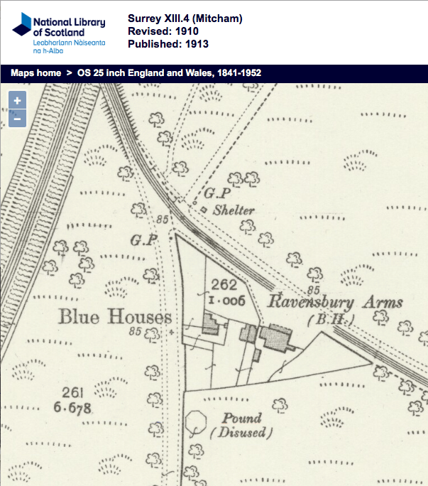
Carshalton Road at junction with Croydon Road. The house was one of the Blue Houses. From a Percy Mayhew postcard, from Merton Memories, photo reference Mit_19_1-19

The guide post (marked G.P.) that is on the south side of the tram line in this 1910 OS map is the one seen in the photo.

1910 OS map

The junction with Croydon Road was changed to a roundabout in 1955.

From the Mitcham News & Mercury, 24th February 1955

ROUNDABOUT

Work is to start soon on making a traffic roundabout at the busy junction of Croydon Road with Carshalton Road, on Mitcham Common.

The Transport Minister has approved a grant of up to £4,427 towards the cost of the roundabout. Coun. D.J. Hempstead, Highways Committee chairman, said last week that it was hoped that work would be speedily undertaken.

The bridge over the railway line was widened at the same time, the work having been started in 1939 but was interrupted by the war.

On the east side of Carshalton Road, south of the railway station, was a WW2 anti-aircraft gun site. It was cleared in the early 1960s.

1955 OS map showing the Gun Site.

From the Mitcham News & Mercury, 13th July 1962:

At last – Gunsite is to go

One of Mitcham’s biggest eyesores, the Gun Site, Carshalton Road, Mitcham Common, is at last to be cleared at a cost of about £13,000.

Work on clearing the site is expected to start in about two months time.

The Ministry have approved a tender of £10,800 submitted to them from the Conservators and have further agreed to bear the cost of replacing trees on the site.

WELCOMED

A further cost of £2,000 fees will be included in the work.

This news is welcomed not only by the Conservators but by Mitcham Council and the public.

The Gun Site is one of the few remaining war relics in Mitcham and local people have been pressing for years to clear it.

The conservators hope to replace it with a grass landscape with trees.

WW2 Civilian Casualties

20th October 1940

16 Carshalton Road
Winifred Mabel LARBY, aged 35


Maps are reproduced with the permission of the National Library of Scotland.