Road that continues eastward from Locks Lane to the level crossing at Mitcham Eastfields station. All properties currently have the postcode CR4 2LS.
On this 1953 OS map, houses, that are only on the north side of the road, are numbered eastward as odd from 13 to 91. As described from west to east:
a terrace of 4 houses, numbers 13 to 19;
a separate building numbered 21 which had been used as a shop with accommodation, see below;
footpath to Sandy Lane (now Public Right of Way 147);
a row of 6 houses numbered 27 to 37;
number 39 was demolished due to bomb damage in WW2;
a gap which is now Roper Way;
a terrace of 5 houses numbered 49 to 57;
a terrace of 3 houses numbered 59 to 63;
a terrace of 3 houses numbered 67 to 73;
then Rialto Road;
a terrace of 4 houses divided into 2 flats each, numbered 75 to 91.

1953 OS map
This earlier OS map from 1894 shows that the road was part of Tamworth Lane, separated from the rest of it by the railway that was constructed in 1868.

1894 OS map
The 1914 electoral register lists the following occupants in Eastfields Road:
Martin’s Cottage, Edward ROGERS
Primrose Cottage, Richard TOOGOOD
Bird’s Cottage, James McATTEER
10 Rosemary Villas, Charles WILSON
9 Rosemary Villas, John GODDEN
7 Rosemary Villas, George Wheldon HEPWORTH
6 Rosemary Villas, Henry WOODS
4 Rosemary Villas, John Frederick WADE
1 Rosemary Villas, William Valentine BENSTEAD
George TURNER is listed as Eastfields Road only
The 1925 street directory lists properties from Lock’s Lane:
Richard C. TOOGOOD, shopkeeper
Rosemary Villas
10, George Wheldon HEPWORTH
9, Samuel AULD
8, James SULLIVAN
7, Mrs WILSON
6, Mrs WOODS
5, Albert Edward MEPHAM
4, Percy Charles RIGGS
3, Andrew DUNNING
2, Henry WOODS, pig dealer
1, William V BENSTEADKirby Cottage, Charles DAVISON, stock breeder
George Wheldon HEPWORTH had married Elizabeth Amelia WOODS, daughter of Henry WOODS, in 1911. The Henry Woods at no. 2 in the 1925 directory was his son, as Henry Woods senior died in 1922.
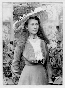
Elizabeth Hepworth nee Woods. Photo kindly provided by a descendant of the family.
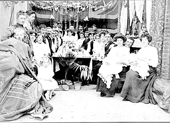
Woods family gathering, believed to be in Rosemary Villas. Photo kindly provided by a descendant of the family.
The road was renumbered in 1929/30 as the 1929 electoral register shows these named houses, but the 1930 register and onwards show them as numbered.
This table shows the number or name of the house in 1929, then the number in 1930 and the surname of the occupants in 1930.
| 1929 | 1930 | Occupants |
|---|---|---|
| 1 | 13 | MILLER |
| 2 | 15 | PENEGAR |
| 3 | 17 | EDWARDS |
| 4 | 19 | SCOTT |
| Stables | Stables | GUYATT |
| Primrose Cottage | 21 | TOOGOOD, STEWART |
| 10 Rosemary Villas | 33 | HEPWORTH |
| 9 Rosemary Villas | 35 | AULT |
| 8 Rosemary Villas | 37 | SULLIVAN |
| 7 Rosemary Villas | 39 | EXCELL |
| 6 Rosemary Villas | 47 | WOODS |
| 5 Rosemary Villas | 49 | MEPHAM |
| 4 Rosemary Villas | 51 | RIGGS |
| 3 Rosemary Villas | 53 | DUNNING |
| 2 Rosemary Villas | 55 | WOODS |
| 1 Rosemary Villas | 57 | BENSTEAD |
| Kirby Cottage | 65 | DAVISON |

1934 OS map
Eastfields Corner
These houses, numbers 13, 15, 17 and 19, were owned by Renshaw, the marzipan factory in Locks Lane and initially rented out to staff. It was known as “Eastfields Corner”.
No. 21
The shop at no. 21 used by John Jayson after WW2. He had originally a grocers shop at 2 Fernlea Road which had been bombed in the war. A fellow on the Facebook group Mitcham History said that there was a wood yard at the back where, as a child, he would take cardboard for it to be weighed and exchanged for a few pennies.
The shop became a newsagents/confectioners/tobacconist in 1957. It was Rogers Estate Agents, between 1959 and 1989, when it estate agency was sold to Dunley. Thanks to Tony Rogers for this information, see his comment below. Listed in the 1973 Mitcham Chamber of Commerce booklet with telephone number 648 8527, and shown in this 1959 ad:
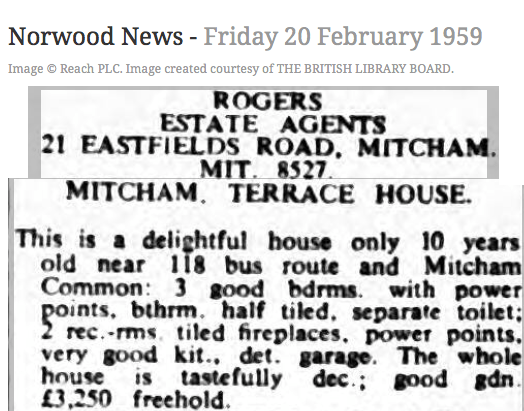
20th February 1959 ad in Norwood News
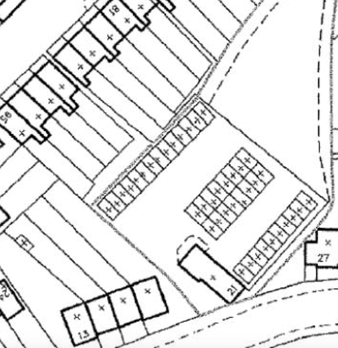
In March 1954 planning permission was given for 40 lock-up garages to be built at the rear and side.
This property was in use as an estate agents up to 2002, after which it was empty and was bought by Merton Council with a Compulsory Purchase Order on 17th December 2009. It was redeveloped in 2014 as flats, as described in planning application 13/P1383:
Demolition of the existing two-bedroom property at 21 Eastfields Road and the adjacent 40 domestic garages and construction of a new three-storey building providing 21 flats [9 three bedroom flats and 12 one bedroom flats] with 14 off street car parking spaces with vehicular access on to Eastfields Road, landscaping and a freestanding building providing cycle and bin storage.
The flats are numbered sequentially from 1 to 21, with the address of 21 Eastfields Road.
39
This house was added to the row of 6 houses numbered 27 to 37 in around 2009/10, as described in planning application 09/P0193:
Erection of a part one, part two storey end of terrace 2 bedroom dwelling house
The original number 39 had been damaged in WW2, and the rebuilt house reproduced the frontage in keeping with the rest of the terrace:
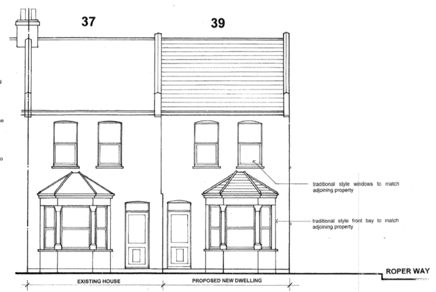
Front elevation of no. 37 and 39 from planning application
71
At number 71 was W. Steptowe & Sons, boot and shoe repairers.
News Articles and Ads
The newspaper articles below are via the British Newspaper Archive
From The Evening Herald (Dublin) Saturday 30th August 1930
A few minutes after Mr and Mrs Albert EXCELL and their five-year-old son, Johnny, of Eastfields Road, Mitcham, had left their bedroom at 2 a.m. the house was struck by lightning and plaster fell in large sheets from the ceiling on to the bed.
Newsagents T.G. COOPER, 96, Eastfield Road, stocked ‘Action’, a newspaper of the British Union of Fascists, according to this ad of 23rd July 1938:
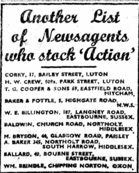
23rd July 1938 ad in Action
Maps are reproduced with the permission of the National Library of Scotland.
