Tag Archives: 1895

256 and 254 London Road

Building divided into two shops with flats above, on west side of London Road, opposite the White Lion of Mortimer pub (formerly the Bucks Head). Numbered from north to south, 254 is on the right and 256 on the left as viewed from the street. Before 1926/7 this part of London Road was called Mitcham High Street, and the numbers ran south to north.

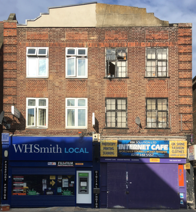
256 on left and 254 on right, London Road, Mitcham. Photo taken August 2017.

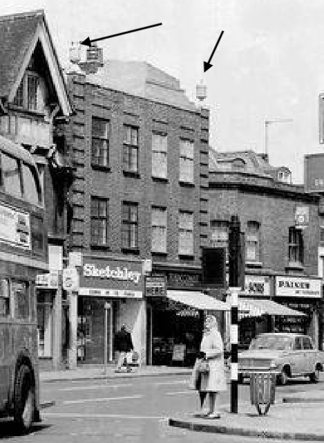
This photo, before 1980 or so, showed two features on the top of the building:

This photo from 1895 shows that before this was built stood the drapery shop of Mrs Lack and Mr Cummings greengrocers, see directory listing below.

1895 clip of Merton Memories photo reference Mit_​Streets_​Lon_​38-14 copyright London Borough of Merton

Before being renumbered in 1926, this part of the London Road was called Mitcham High Street. From the 1891 directory (the shops were numbered from 1 going north):

1, Henry COLLBRAN, butcher
2, S.E. BURTON, stationer
3, Charles GOULD, The Kings’ Arms Public House
4, Mrs H. LACK, draper
5, John CUMMINGS, greengrocer
6, Joseph COOK, butcher
7, T.P. SHEPPARD, grocer
8, William BARTER, grocer
9, George Joseph DALE, news agent

— here is Sibthorpe Road

In the 1930 commercial directory, John CUMMINGS is still listed as greengrocer at number 254, hence 4 High Street became number 256.

In the 1938 commercial directory, A. Lewis and Co. (Westminster) Ltd., is listed as tobacconists at number 254


Maps are reproduced with the permission of the National Library of Scotland.

Byegrove Road

Road off of Colliers Wood High Street that was part of the Mitcham Urban District. Possibly named after the nearby Byegrove House, as shown in this 1865 OS map.

1865 OS map

This 1895 OS map shows houses only on the south side of the road.

1895 OS map

The OS map of 1911 shows houses have since been built on its north side.

1911 OS map

Note also that on the left is Bailey Road, which no longer exists.

From the 1911 street directory, as described from the High Street:

SOUTH SIDE
3A, William MASON shopkeeper
………Here is Bailey road………
1 George WATKINS, beer retailer
…… here is public footpath to Wandsworth ……

Croydon Rural District Council Sewage Works
(Henry James SNOOK, farm manager; John Alfred SUTTON, engineer)

NORTH SIDE
…… here is Denison road

Occupants in the 1925 street directory

East Side
2,George RIDOUT
2a,Sidney SMITH
4,Harry JOHNS
4a,Mrs RICHARDS
6,Walter Edward TRIGGS
6a,Frank GOVER
8,Frederick SUTTON
8a,Mrs ARNOLD
10,Mrs CLARKE
10a,Edwin JONES
12,William HOLLEY
12a,Ernest BLOW
14,Charles WOODS
14a,Arthur VARRALL
16,Frederick CROSBY
16a,William Charles STEWART
18,Thomas RUSSELL
18a,Harry MITCHELL
20,Frederick Joseph DENNIS
20a,William Isaac FAIR
22,William GILBERT
22a,George RANDALL
24,Thomas PRICE
24a,Henry Samuel HALL
26,Seymour SCOTT
26a,Sidney COPPERWAITE
28,Henry TIBBLES
28a,George JONES
30,Gordon James SCRUBY
30a,William BRYANT
32,Herbert Charles LEVISH
32a,Mrs FLEMING
34,Mrs KNIGHTBRIDGE
34a,Henry GUY
36,H. Sermon KNIGHTBRIDGE
36a,Alfred John SIMONS
38,Frederick William KING
38a,John SPICE
40,Aesbsell PROCKTER
40a,George Arthur WEBB
42,George PETERS
42a,Richard LUCRAFT
44,Mrs STEIDLEN
44a,Thomas LEWMAN
46,Arthur George CLARKE
46a,Ernest STAPLES
48,Mrs DREW
48a,Mrs BLOMFIELD
50,Mrs MARK
50a,Mrs WALKINGTON
52,Ernest FERRIDGE
52a,William GEORGE
54,Alfred Edward RISK
54a,Percy Harold SMITH
56,Edwin Charles WALLER
…. here is Denison rd

West Side
3a, N. SIMS,shopkeeper
…. here is Bailey Road
1,A.E. HELLEWELL ,beer retailer
5,Ernest Edward ROFFEY
7,Arthur PENTLOW
9,Edward James SPICE
11,Archibald HOLLEDGE
13,Charles HAWKINS
15,George BARRETT
17,Henry GARDNER
19,Mrs MEAD
21,Walter ROFFEY
…. here is public footpath to Wandsworth
Wandle ValleySewage Works
(Jolm Alfred Sutton, engnr)

The 1950 OS map shows the house numbering. Note 3A on the corner with Bailey Road, and that the north side are all even.

1950 OS map


Maps are reproduced with the permission of the National Library of Scotland.