Tag Archives: gas lamp

Lower Green Public Conveniences

Built around 1929 underground, opposite the Burn Bullock, and behind the water trough.

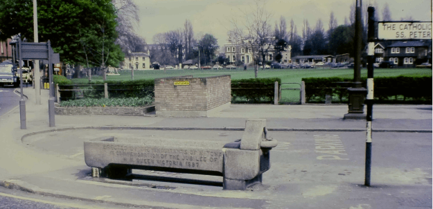
Clip of 1975 photo taken by Bill Rudd, and reproduced here by kind permission of the Merton Historical Society

The gas lamp post shown between the toilets in this photo was added to the local list by Merton Council on 12th July, 2017, as a result of a campaign by Mitcham Cricket Green Community & Heritage.

The need for a public convenience at this spot was debated in 1923.

From the minutes of the Mitcham Urban District council
Volume IX April 1923 to March 1924
Pages 291 to 292

Report of Sub-Committee appointed to consider the question of the provision of Public Conveniences.
Meeting held Monday, October 15th, 1923.

Present : Mr. R. F. Langley (Chairman), Messrs. H. J. Davis, J. Fitch and W. H. Parslow.

The Sub-Committee considered the matter referred to them by the Public Health Committee, and beg to submit the following suggestions :-

1. The need for public conveniences in certain parts of Mitcham is becoming more and more apparent every year, and with the constant increase in the number of visitors brought into the district by the omnibus and tramway services it is essential that the matter should be taken in hand at a very early date.

2. The Sub-Committee consider that the most pressing needs are for public conveniences (for both sexes) upon the Fair Green and the Lower Green.

3. The site upon the Fair Green has already been determined by the Council, and the plans of the Surveyor have been the matter is now before the Ministry of Health.

4. The provision of a convenience on the Lower Green is, therefore, in the opinion of the Sub-Committee, the most pressing need at the present time. every day a large number of persons are brought to this spot owing to its being the terminus of a well patronised bus service.

5. The Sub-Committee suggest that the most suitable site for a convenience is upon the triangular piece of ground, now planted as a shrubbery, between the ” Cricketers ” Inn and Messrs. Barclays Bank ; and the Committee further suggest that a convenience constructed upon this site could be of an external design which would be in no way a disfigurement to the Green.

6. The Sub-Committee look upon the provision of a convenience in the vicinity of the omnibus terminus as an essential.

From the minutes of the Mitcham Urban District council, volume XIV, 1928 to 1929, page 124:

32. PUBLIC CONVENIENCE, Lower Green. – It was Resolved, That the Council be recommended to instruct the Surveyor to report as to suitable sites for a public convenience on or adjacent to the Cricket Green.

The council had also considered removing the water trough, but held off until they could get agreement on widening the London Road.

In considering the sites for the toilets, the council considered next to the Cricketers pub, and the island opposite Barclays Bank. Page 201 of the above minutes says:

An overground convenience … would destroy the amenity of this corner of the Cricket Green

The problem with an underground convenice though was the cost, as Riley Schofield concluded:

I would like to point out to the Committee that underground conveniences are a very costly proposition. The site will have to be wholly excavated and carted to tip. The walls must be constructed as retaining walls, and also covered on the outside with asphalte to render the structure waterproof. The roof will have to be constructed of
reinforced concrete and provided with prismatic pavement lights, or, as an alternative, the structure could project 2 feet or so above the ground and be lighted by means of lantern lights. Steps will have to be provided, and these are costly and wasteful of space. Ventilation is also an expensive item. It may be necessary to raise the sewage by
mechanical means, necessitating a constant charge for the supply of water.

The decision to go with an underground convenience, behind the water trough, was made and reported on pages 276 to 277, although the Surveyor was asked to provide estimates for a partially underground as well wholly underground. Page 451 shows that his estimates were close, £2,100 for partially vs £2,500 for wholly underground, and he recommended the latter. Page 457 shows that the council agreed with his recommendation.

In volume XV, 1929 to 1930, page 104, the council asked the Ministry of Health for a loan of £3,500 to build the underground public convenience. Adjusted for inflation, this is equivalent to around £200,000 in 2017 values. Page 207 shows that the Ministry approved the loan and so the Surveyor was instructed to put it out to tenders. Page 311 reports that 11 firms had submitted tenders for the job, and that the Horley firm of Mr J. CREWDSON had been accepted, for the amount of £2,672. The Horley Local History Society has more on this builder, who also has a road there named after him.

No further details are available in council minutes as to when the convenience was completed.

From the minutes of the Mitcham Urban District council
Volume XVI, 1930 to 1931
Page 178

9. PUBLIC CONVENIENCE The Surveyor reported that he would find it necessary to engage the services of a full time attendant at the public convenience on the Lower Green, and that the annual cost thereof would amount to £352, this being a sum somewhat in excess of the original estimate. Resolved, That the Surveyor be authorised to make the necessary appointment.


Minutes of meetings held by the Mitcham Urban District Council are available on request from the Merton Heritage and Local Studies Centre at Morden Library.

Langdale Avenue

A cul-de-sac road, off of London Road north of the telephone exchange, with its southern, closed end at the Cold Blows footpath.

Houses are numbered from the London Road end, odd on the left (1 to 95) and even on the right (2 to 84). In 2019, a Royal Mail postcode lookup shows 87 addresses, and 4 postcodes, CR4 4AE/F/G/J. Some houses have been converted into flats.

The name comes from the Langdale family who owned Elmwood (previously called The Firs), an 18th century house, sold in 1822. Albert Road, Elmwood Road, Langdale Avenue and Whitford Gardens are all built on the site of the Elmwwod estate. The family were related to Marmaduke Langdale, who fought on the Royalist side in the English Civil War.

In this 1910 OS map, the terraces have houses numbered odd from 1 to 11, then after a narrow alleyway 13 to 19, and are the only houses shown on this side of the road.

1910 OS map

The 1910-1911 street directory shows the occupants:

1, Frederick Arthur LOOSLEY
3, Edward James WILLIS
5, Alfred Albert Henry COOPER
7, Raymond REED
9, Rev. Wallace PERRY, B.A.
11, Mrs ACOCKS
15, John William MOORE
17, James HARDING
19, Frederick HAZELL

Next is a pair of semi-detached houses numbered 21 and 23. Then is a terrace of four houses, numbered 25 to 33, after which is a public footpath leading to Commonside West.

Land at the rear of Newton House was developed as a pair of semi-detached houses as numbers 49 and 51, according to planning permission MIT1986, which was granted retrospectively on 27th March 1953.

Next are two more pairs of semi-detached houses, numbered 53 and 55, 57 and 59. After this are terraces, divided by small alleyways: 63 to 67, 69 to 75, 77 to 81, 83 to 95 which is at the end of the road next to the Cold Blows path.

Number 93 on the left has the builder initials H.H. in the gable, and number 95 has the year 1907.


On the right hand side, from the London Road end, is an alleyway that still has cobblestones on the footpath at its entrance. Then there is a terrace, numbered 2 to 12, and in 1911 the occupants were:

2, Frederick James CHARMAN
4, George D.N. FORD
6, Thomas HARRIS
8, Miss CLAYTON
10, John William COULSON
12, John Hunter RIGDEN

The 1910 OS map showed a gap between these houses and Elmwood Road, after which is a terrace that curves right with the road. The houses are currently numbered 22 to 34, but originally they had names as shown in the 1911 directory:

The Lees, Walter HOGG
St Brelades, Walter ATTWOOD
Woodlands, John McLennon JONES
Moss Dale, Louis BRIGDEN
St. Leonards, Henry MOYCE
Chamonix, William Arthur GREGORY
Glenroy, Walter Edgar WARNER

There are no more houses shown on this side of the road on the 1910 map.

From a postcard dated 1916. Houses currently numbered, from right to left, 22 to 34, with the junction with Elmwood Road out of shot on the right. These houses had names at the time of this photo.

1953 OS map

Next is a terrace of six houses numbered 38 to 48. The 1937 electoral register 38 as occupied by John Kentish and Alice Mary HARVEY, with John Kentish junior and Lawrence Reginald Harvey. J.K. Harvey had the chemists at the Fair Green up to 1966.

Then there is a terrace of ten houses from 50 to 68, followed by a pair of semi-detached houses numbered 70 and 72, then a terrace of six houses numbered 74 to 84, which is the end of the road at the Cold Blows footpath.


From the minutes of the Croydon Rural District Council
Volume IX 1903 – 1904
7th May 1903
page 72

No. 2506, Harding, J., 12 houses, Langdale Avenue, Mitcham

From the minutes of the Mitcham Urban District Council
Highways, New Streets and Buildings, and Lighting Committee
Tuesday, 8th June, 1926
Page 120

Plans submitted for approval

No. 808
Applicant: Mr. Isaac Wilson, The Hut, Commonside East
Nature and Situation:

Amended layout for five houses, Langdale Avenue (for subsidy)


World War 1 Connections
Private W Bassett

Private V W Jones

News Articles

1921 suicide in Langdale Avenue explained

Lamp Explodes

A gas street lamp in Langdale Avenue, Mitcham, exploded on Thursday last week – startling people in nearby homes. A jet of flame flared from a broken pipe until Gas Board engineers arrived. Firemen stood by.

Source: Mitcham News & Mercury, 5th June, 1959, page 1.


Occupants in 1925

2, Miss E. ELLIOTT (school)
3, Ernest Edward JONES
5, Alfred Albert Henry COOPER
7, Hugh CLAYSON
9, Donald HADFIELD
11, Mrs DODD
13, Henry George RUSSELL
15, William James BIGSBY
17, William ANSTEY
19, William Bernard FARADAY
21, Charles Henry PARSLOW
23, Albert George WELLS
The Bungalow, Raymond Edgar REID

4, Edwin George CARD
6, Frederick G. CULMER
8, Misses A.R. & C.C. CLAYTON
10, Thomas FRANCIS
12 Charles E. JENNER
… here is Elmwood Road
The Lees, M. ALLSOP
St. Brelades, Walter Charles BATCHELOR
Woodland, Samuel MICHIE
Moss Dale, Robert WALLS
32, Frederick Richard CANN
34, James Alexander CORMACK
36, John Kentish HARVEY
38, Bodwin SELIER
40, Mrs MILLER
42, Mrs L.E. BEACON
44, John Stuart CAPBELL
46, Alfred John KNIGHT
48, Philip HARDING
50, Mrs COOPER

Number 6 had the name Iveldene according to the 1937 Mitcham Cricket Club Yearbook that listed R.S. Culmer as the club’s Hon. Secretary.

WW2 Civilian Casualties

18th September 1940

Doris Christine ORSON, aged 42 and Nelson Humphrey ORSON, aged 49, both at 7 Langdale Avenue

Mary Maud WEBB, aged 68, 9 Langdale Avenue


Minutes of meetings held by the Croydon Rural and Mitcham Urban District Council are available on request from the Merton Heritage and Local Studies Centre at Morden Library.


Maps are reproduced with the permission of the National Library of Scotland.