A booklet from 1973 that put forward 4 plans for the town centre:
Plan 1, Plan 2, Plan 3 and Plan 4.
EXHIBITION
A public exhibition of the proposals contained in this booklet will be held at the London Electricity Board showroom, 1-2 Fair Green Parade, Mitcham, on the following dates and times:-
Friday, 6th July 9 a.m. to 8 p.m.
Saturday, 7th July 9 a.m. to 5.30 p.m.
Friday, 13th July 9 a.m. to 8 p.m.
Saturday, 14th July 9 a.m. to 5.30 p.m.
Members of the Town Planning staff will be available to explain and discuss the proposals informally.
PUBLIC MEETING
Following the exhibition a public meeting will be held to discuss the proposals at The Vestry Hall, Cricket Green, Mitcham at 7.30 p.m. on Friday, 20th July. The Chairman for the meeting will be Alderman R.F. Franks, Chairman of the Town Planning and Development Committee.
COMMENTS
A reply paid form will be found at the end of this booklet. Please write your comments on the proposals on this form and leave it at the exhibition in the box provided or post it to the Borough Surveyor. No stamp is required.
Please ensure that the form is returned by 31st August 1973.
THE PLAN FOR MITCHAM WILL AIM TO MAKE IT A BETTER PLACE IN WHICH TO LIVE AND WORK. YOU CAN HELP SHAPE THE TOWN’S FUTURE BY CONSIDERING THESE POSSIBILITIES AND LETTING THE COUNCIL KNOW WHAT YOU THINK OF THEM.
A PLAN FOR MITCHAM TOWN CENTRE
The Council of the London Borough of Merton is in the process of preparing plans for the future of Mitcham Town Centre. This booklet is being distributed to all homes and commercial premises in and surrounding the centre and, together with an exhibition and public meeting, will give everybody concerned the chance to study and comment on the plans which are being considered.
In July 1972 a leaflet was published which outlined the Council’s ideas and aims regarding the Town Centre. Comments from local residents and groups on these aims were taken into account in preparing the four different plans which are shown in this booklet. Your comments on these proposals will help the Council to identify a preferred plan. This will be considered in greater detail and then published for your information and observations.
No phasing or programming proposals are included at the present time and these will become clearer when further information on the Greater London Council’s road policies and finance are available.
SURVEY MATERIAL
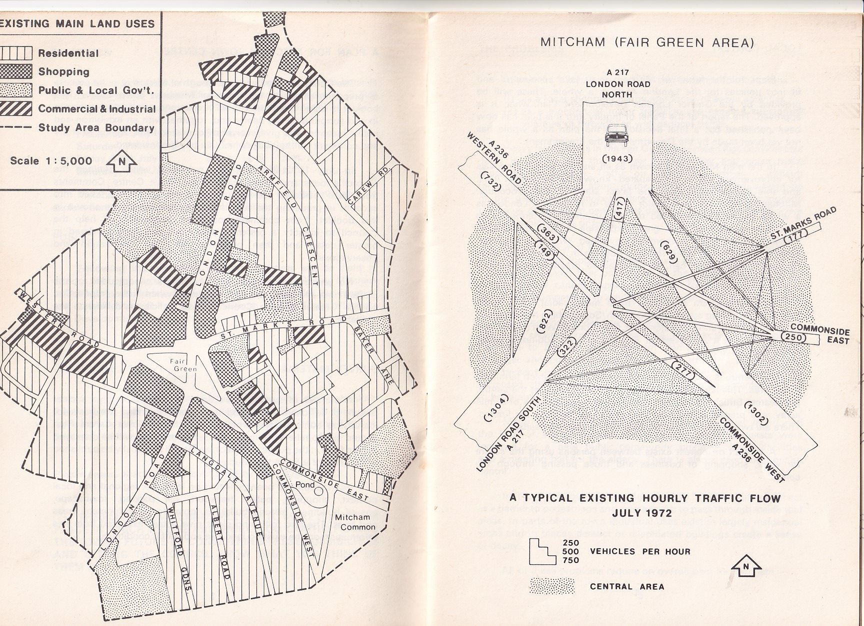
A number of surveys have been carried out to give a clear picture of Mitcham today and these have provided the basis for identifying some of the problems which the Town Centre Plan should aim to relieve. Much of the survey material will be displayed in plan form at the public exhibition and it will eventually be published in the form of a Report of Studies.
Information has been collected on land use, regional and local context, shopping, public transport, car parking, townscape, age of buildings, historic buildings, possible redevelopment areas and trees. The two following plans give details extracted from this information on the existing land use and traffic conditions.
LOCAL CONTEXT
Plans for the future of Mitcham must take account of and fit into policies for the London Area as a whole. These will be provided by the Greater London Development Plan when it is approved. The report of the Panel of Inquiry into this plan has now been published but a final decision on the plan as a whole has not yet been made by the Department of the Environment.
In the plan Mitcham is shown as an area for which proposals for improvement are to be prepared, known as an Action Area, and this booklet represents the latest stage in this procedure. Mitcham is not seen as a major centre in relation to London as a whole but will be expected to cater in shopping terms for its immediate population. No great expansion of the commercial activities of the town is therefore envisaged. On the other hand there is a continuing need for new housing in London and plans for the Mitcham area can be expected to provide opportunities for building new homes.
Central Mitcham is divided by a major radial traffic route (the A.217) running approximately North/South which has junctions at Fair Green with another major route, Commonside West (the A.236). Commonside East and Western Road also bring additional traffic to the Fair Green area.
The centre is served by ten bus routes, four of which terminate in the area. This is the only public transport available at the centre, the nearest British Rail station being some three quarters of a mile away, and present operational and passenger facilities are limited. There are two public car parks which satisfy existing needs.
A conflict of interest exists between persons using the centre for work, shopping or business and those passing through the centre.
THE PROBLEMS
At present Mitcham has to fulfil two incompatible functions:—
(i) as a local shopping centre and focus of social activities.
(ii) as a junction of major traffic routes carrying substantial volumes of through, as well as local traffic.
Heavy traffic flows in the Fair Green area mean that considerable delay is caused and that danger, fumes, dust and noise make shopping unattractive. Traffic on Fair Green makes it difficult for shoppers to move about in the centre and take full advantage of the goods and services offered. The Green itself, historically the focus of the town centre, has become a noisy and unattractive place in which to sit or relax.
The attraction of Mitcham as a local centre is also limited by a lack of variety of shops. This point clearly emerged as a result of the comments received after publication of the previous leaflet. Whilst a local centre cannot expect to provide for all purchases some variety and competition in day to day shopping should be achieved.
Mitcham has a definite sense of scale and character which has been retained over the years by small scale redevelopment restricted to the old street pattern. Some recent redevelopment of larger shopping frontages has tended to erode this character and present day pressures for large scale redevelopment make increased attention to building form and design essential if it is to be retained.
Many of the comments on the previous leaflet mentioned the lack of social facilities in the town centre. Requests were received for a new public/community building, sports facilities and a meeting hall for the elderly. There is also a need for a health centre.
In the areas outside the centre itself again main roads act as a barrier to pedestrians and cause traffic to pass through residential areas. In parts of the town industrial uses exist in largely residential areas and in places derelict or dilapidated buildings create a sense of decay.
All of these problems require an overall plan for Mitcham.
IDENTIFICATION OF AIMS
As a result of the study of existing problems, and the replies to the previous leaflet, the following aims for the Town Centre Plan have been identified:—
(1) To enhance the intimate scale and character of the town centre in accordance with its primary function as a local shopping centre;
(2) to provide for some modest increase in shopping and office development, compatible with the character of the area, to maintain and improve the economic viability of the town centre;
(3) to encourage increased low rise residential development at increased densities to replace any houses lost as a consequence of redevelopment;
(4) to encourage the provision of social and recreational facilities for a variety of age groups;
(5) to provide maximum accessibility by public transport for users of the town centre;
(6) to provide adequate private and public car parking facilities for users of the town centre;
(7) to provide a highway system –
(a) aligning principal traffic routes so as to exclude through traffic from the shopping area;
(b) segregating, as far as practicable, pedestrian and vehicular traffic; and
(c) encouraging the provision of service facilities for existing and future shop and commercial development.
These do not however take account of the effects that the proposals will have on the areas surrounding the centre and ac-cordingly the following three aims have been added to ensure that the disadvantages to these areas, stemming from the proposals, are fully recognised
(8) to minimise the effect of road and other proposals on the surrounding residential areas by means of noise, visual intrusion, loss of open space and amenity areas or severance of pedestrian routes to the Town Centre;
(9) to minimise the effect of road and other proposals on the Merton (Mitcham, The Cricket Green) Con¬servation Area, within which a policy of retention and enhancement of the existing character is pursued;
(10) to minimise the effect of road and other proposals on the secondary shopping areas outside the Town Centre by reason of increased traffic, difficulties of pedestrian access or loss of trade.
The proposals which follow should be looked at in relation to their achievement of these aims.
THE PROPOSALS
Arising from the problems and aims outlined above a broad picture, or concept, of the future functions and form of the Town Centre has been prepared. These principles are combined on the following pages with various road patterns to provide four different Town Centre Plans.
All of these proposals have different advantages and dis-advantages and the Council will take into account your comments and suggestions in preparing its plan.
THE CONCEPT OF THE TOWN CENTRE
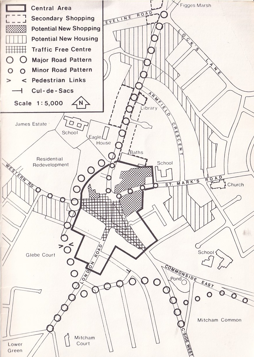
Much of Mitcham’s existing character arises from the fact that it is a well defined settlement with an identifiable central area. Figges Marsh, Mitcham Common and The Cricket Green all help to define the limits of the centre and the core of the town is situated around Fair Green thus retaining its historical form. Concentrating town centre uses around the Fair Green will, if adopted, help to strengthen this aspect of the town’s character.
Within the central area shown opposite should be located the principal shopping and commercial uses of the town. Re-development in this area must, however, reflect the existing scale and character. The central area should not include any element of through traffic but maximum accessibility by public transport, and on foot, should be provided.
Areas outside the centre should be largely residential in character and sites which may become available for redevelopment would be used primarily for housing purposes.
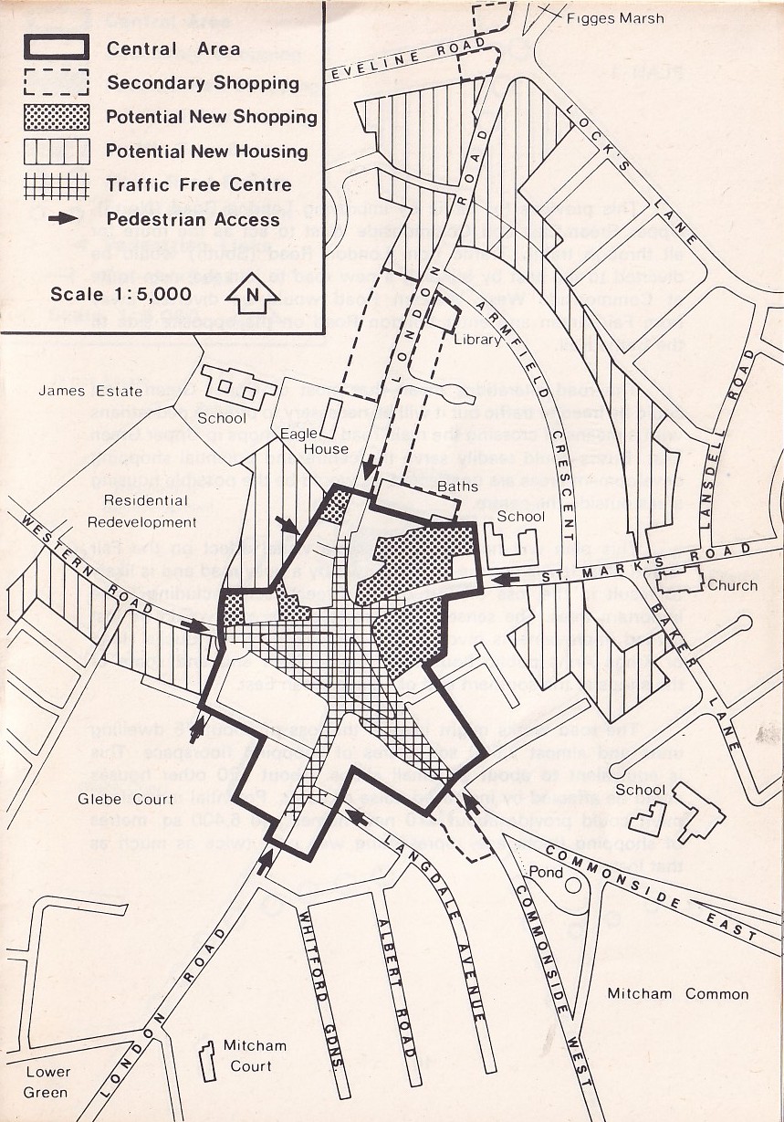
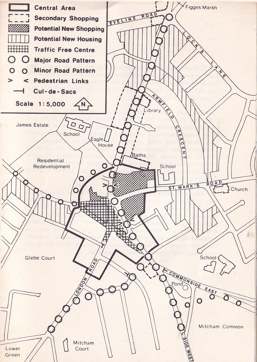
PLAN 1
This provides for traffic by improving London Road (North), Upper Green East and Commonside West to act as the route for all through traffic. Traffic from London Road (South) would be diverted to the east by building a new road to join the main route at Commonside West. Western Road would be diverted away from Fair Green and enter London Road on the opposite side to the Baths Hall.
The road alterations mean that most of Upper Green West could be freed of traffic but it will be necessary to provide pedestrians with a means of crossing the main road to the shops in Upper Green East. Buses could readily serve the centre and potential shopping development areas are unaffected, as would be the possible housing areas outside the centre.
This plan will have a considerable visual effect on the Fair Green area. It will cut the centre in two by a busy road and is likely to result in the loss of part of the Green itself, including some important trees. The sense of enclosure of the area would be lost if road improvements involved the demolition of the Bucks Head or Kings Arms public houses at the northern end and some of the shops at the southern end of Upper Green East.
The road works might involve the loss of about 75 dwelling units and almost 2,500 sq. metres of shopping floorspace. This is equivalent to about 25 small shops. About 120 other houses could be affected by increased noise or traffic. Potential redevelop¬ment could provide about 410 new homes and 6,400 sq. metres of shopping floorspace, representing well over twice as much as that lost.
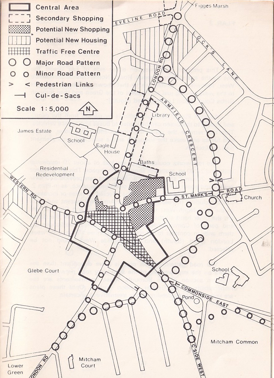
PLAN 2
This utilises the Elm Allotments and the vacant land to the south as the line for a by-pass of the Town Centre. The road would then pass east of Fair Green, making use of existing undeveloped land behind Baker Lane to join Commonside West and then link to London Road (South).
The plan provides the opportunity to remove all through traffic and thus limit traffic in the centre. Access for buses and some service vehicles would be required but much of the Fair Green could become a pedestrian precinct. This would create a much safer and more pleasant environment for shopping. The character of the Green would be greatly improved and could be laid out with much more sitting and recreation space. However such a road provides a barrier to pedestrian movement between Fair Green and the Common and some of the character of the northern end of the Conservation Area will be lost.
The road works could involve a loss of about 70 residential units and 1,000 sq. metres of shopping floorspace. This represents about 10 small shops. New development could provide 330 new homes and 5,400 sq. metres of shopping floorspace, in other words about two large supermarkets or a much larger number of smaller shops. Some 230 other houses would be affected by noise or increased traffic, mainly in the blocks of flats off Armfield Crescent. Measures would need to be taken to reduce this effect by careful road design and noise insulation to properties.
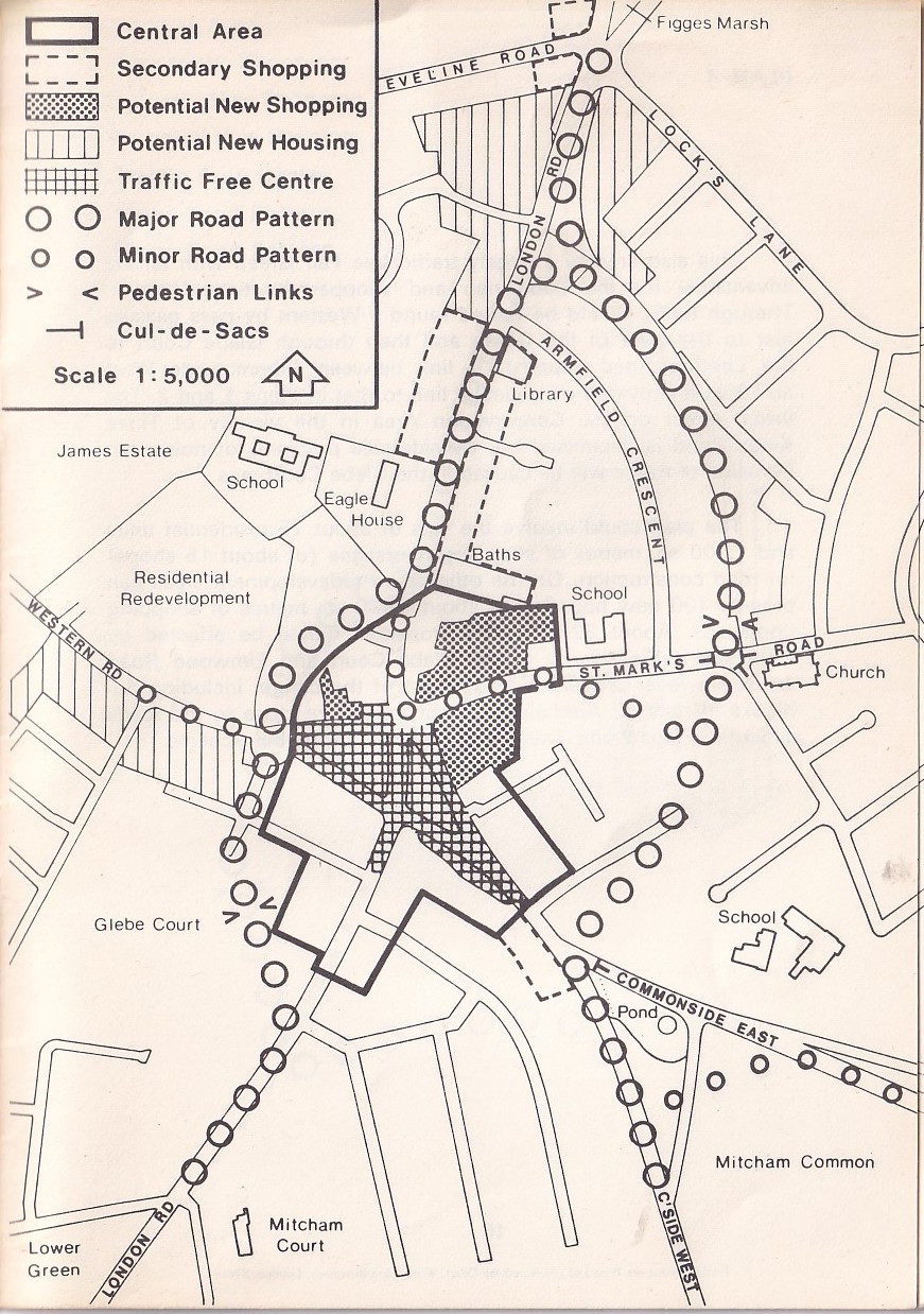
PLAN 3
This provides a by-pass on either side of Fair Green, the one to the east linking London Road (North) with Commonside West, following a similar line to that shown in Plan 2 and that to the west passing just to the west of the Green and then through Glebe Court to join London Road (South).
As with Plan 2 through traffic is by-passed from the centre and access to the Green can be limited to buses and service vehicles. This will remove the great majority of the traffic noise, danger and fumes and make the shopping area a safer and more pleasant part of Mitcham.
The roadworks could involve the loss of about 70 residential units and 2,200 sq. metres of shopping floorspace. This is equivalent to about 20 small shops. New development can provide 330 new homes and about 5,400 sq. metres of shopping space, as in Plan 2. About 330 other dwellings would be affected by noise or increased traffic including the blocks of flats off Armfield Crescent and parts of the new North-West Quadrant housing area and Glebe Court. On the other hand all the dwellings around the area of the Green and parts of Commonside East would have less traffic passing them and, in contrast to all the other schemes the area between London Road (South) and Commonside West would not be affected.
The road pattern of this plan is more dependent than the others on the improvement of the secondary road network in the southern section of the Borough. These improvements are the responsibility of the Greater London Council. Until these plans are known the practicability of this alternative is uncertain.
PLAN 4
This also creates a largely traffic free Fair Green with all the advantages for the pedestrian and shopper mentioned earlier. Through traffic would be routed round a Western by-pass passing just to the west of the Green and then through Glebe Court to the London Road (South). A link between Commonside West and East is provided on a similar line to that in Plans 1 and 2. The visual effect on the Conservation Area in the vicinity of Three Kings Pond is minimised but considerable problems of noise and intrusion of traffic will be caused in the Glebe Court area.
The plan could involve the loss of about 75 residential units and 1,700 sq. metres of shopping floorspace (or about 15 shops) for road construction. On the other hand redevelopment areas can provide 400 new houses and about 5,400 sq. metres of shopping floorspace. About 325 existing properties would be affected by increased traffic, mostly in the Glebe Court and Elmwood Road areas. However properties to the east of the centre, including the blocks of flats off Armfield Crescent which are close to the roads shown in Plans 2 and 3 would not be affected by this scheme.