Tag Archives: Hackbridge

Notes on Mitcham Common by H.G. Winbow

Published in the South Warder, the newsletter of the South Ward Residents Association in August 1962.

Recently the question arose about the origin of the footpath near the Garden Village from Cranmer Bridge to Mitcham Junction. This path is on the site of the old road and when the London and Portsmouth Railway was constructed across the Common in 1863, the present Cranmer Road was realigned, owing to the sharp curve made to approach the junction of the Wimbledon/West Croydon line which was constructed in 1844.

Recently cars appeared to be using this footpath as a short cut from Willow Lane to Cranmer Bridge, and it is satisfactory to note that the Conservators agreed to the Preservation Society’s request to erect posts here.

Walking round the Common, you notice several old cart tracks, one just the other side of the bridge at Mitcham Junction led to a farm near the railway, this is now known as Aspen Gardens. Further on we come to the concrete road, which is called Drakes Road but nobody seems to know how this road got its name, except that it was the entry to the gravel pits which were worked here for many years.

A short distance from here we see another rough track across the Common, this is called Arneys Lane. At one time this went across the fields to some old cottages near the River Wandle. This track now stops at the footpath which runs along the rear of the houses; the footpath is believed to be on the site of the Surrey Iron Railway branch to Hackbridge.

Not far from here is the “Goat Inn”. Beyond here this part of the Common is called Mill Green and is maintained by Beddington and Wallington Borough Council. But opposite this inn there is another track which follows the southern boundary of the Common. This track ends at the railway, but there is a footbridge here, so one can continue the walk on to Beddington Lane Halt. This is one of the best parts of the Common, right away from any roads.

Some years ago a small area was added, so one can now walk through the avenue of trees to the footpath to Beddington Lane, a very pleasant walk in the summer. From here there is no need to follow the road to the Windmill House, but walk across the Common past the one-island pond, and across the Croydon Road to Commonside East,

Proceeding westwards, we come to the new factory of Tower Creameries, this is on the site of the old workhouse which was built about 1790 and for many years was used by the Woodite Rubber Company’s works. Sections of the first Atlantic submarine cable was supposed to have been made here.

Just near here we see two old cart tracks crossing the recently reclaimed part of the Common, these were used as the entrance to Sherwood Farm.
Crossing Manor Road we come to the rough road which runs along the Common to Commonside East; many years ago some wooden cottages stood here, which might explain how this road came into existence.

Owing to building development on the boundary of the Common, these old cart tracks present a problem. As they are all on Common land the question of keeping them in repair is a difficult point.

Further along Commonside East there is a small pond, known as “Pinnocks Pond”. Years ago opposite here there was a small cottage and market gardens, owned by a Mr. Walsh and later by a Mr. Pinnock; this explains how the pond became known by this name. The road from here across the Common to the “Blue House”, now called Cedars Avenue, was called the New Road by the old inhabitants. The end of this road, of course, brings us to the roundabout and the old wooden cottages, shown on old maps as “The Blue Houses”. It has been said that employees of the Surrey Iron Railway stabled their horses here. This could be true because these cottages are not far from the site of the old iron road.

The old “Ravensbury Arms” was the same as these cottages, the present public house was built in 1906. But a shorter walk can be made by taking the footpath from Beddington Lane over the Common and following the railway, this brings us out via the Golf Club House to Carshalton Road.

This is a nice walk, but I would not advise this way in wet weather as this part of the Common is very rough, owing to the extensive gravel digging that took place here before the Common was controlled by the Conservators. Along this path is where the new footbridge over the West Croydon line has been erected by the Golf Club and which is open to the public.

Gunsite

An area of Mitcham Common that is south of the Mitcham Junction tramstop and railway station, east of the Carshalton Road, and is bounded on its eastern edge by the railway line between Mitcham Junction and Hackbridge stations, and on its southern edge by the scaffolding yards at the rear of the Corporation Cottages.

The area is called the Gunsite after its use during WW2 as an anti-aircraft installation, as shown on this 1955 OS map:

1955 OS map

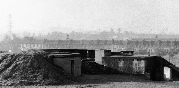
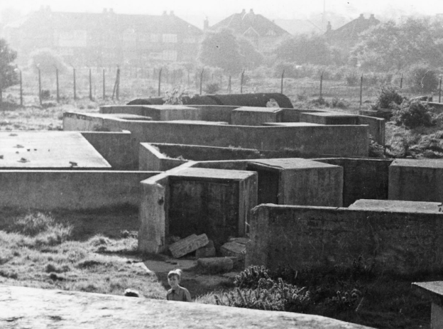
This photo shows what remained of the site around 1961. The view is towards the west and the houses of Carshalton Road can be seen in the background.

c.1961 photo of the Gun site, where children often played. From Merton Memories, photo reference Mitcham_War_5-2

Photo taken around 1961 of the Gunsite. The houses in the background are on Carshalton Road. Clip from Merton Memories, photo reference Mitcham_War_5-1

The Gunsite was demolished in 1962/3.

Mitcham News & Mercury, 13th July 1962.

At last
—Gunsite
is to go

ONE of Mitcham’s biggest eye-sores, the Gun Site, Carshalton Road, Mitcham, is at last going to be cleared . . . at a cost of about £13,000.

Work on clearing the site is expected to start in about two months’ time.
The Ministry have approved a tender of £10,800 submitted to them from the Conservators and have further agreed to bear the cost of replacing trees on the site.

WELCOMED

A further cost of £2,000 fees will be included in the work.

This news is welcomed not only by Mitcham Common Conservators but by Mitcham Council and the public.

The Gun Site is one of the few remaining war relics in Mitcham and local people have been pressing for years to clear it.

The conservators hope to replace it with a grass landscape with trees.

Demolition of buildings on the Gunsite, around 1962/3. In the background can be seen a signal at Mitcham Junction Railway Station, and part of the Mitcham Golf Club building. Clip from Merton Memories, photo reference Mitcham_War_5-3

Currently, the area shows no sign of its wartime use.

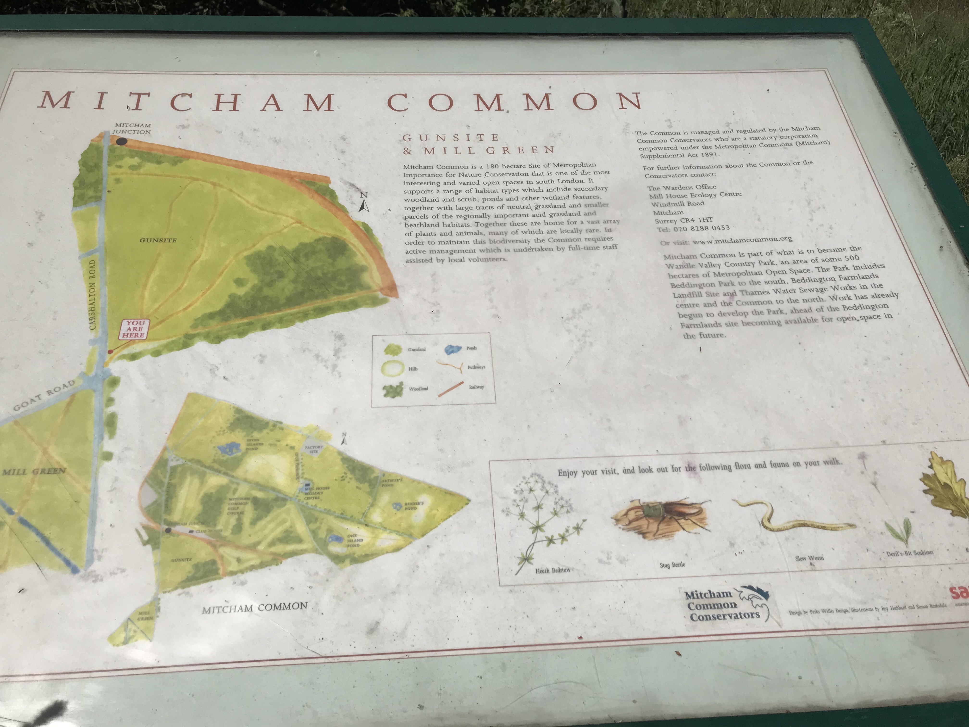
Information Board at the southern entrance to the Gunsite. Photo taken 22nd May 2020.

This board has no date and doesn’t mention the WW2 use of the area, however on the Conservator’s website, suggested walk no. 2, ‘Between The Tramstops’ (pdf) says:

… the area is known as the Gunsite because six anti-aircraft guns were stationed here during the second world war. The troop quarters were still present in the mid-1950s when they were used to house local people while new estates were being built in Mitcham.

The text on the info board:

Mitcham Common is a 180 hectare site of Metropolitan Importance for nature conservation that is one of the most interesting and varied open spaces in south London. It supports a range of habitat types which include secondary woodland and scrub, ponds and other wetland features, together with large tracks of natural grassland and smaller parcels of the regionally important acid grassland and heathland habitats. Together these are home for a vast array of plants and animals many of which are locally rare. In order to maintain this biodiversity the Common requires active management which is undertaken by full-time staff assisted by local volunteers.

The Common is managed and regulated by the Mitcham Common Conservators who are a statutory corporation empowered under the Metropolitan Commons (Mitcham) Supplemental Act 1891.

For further information about the common or the conservators contact :

The Wardens Office
Mill House Ecology Centre
Windmill Road
Mitcham
Surrey CR4 1HT
Tel: 020 8288 0453

Or visit: www.mitchamcommon.org

Mitcham Common is part of what is to become the Wandle Valley Country Park, and area of some 500 hectares of Metropolitan Open Space. the Park includes Beddington Park to the south, Beddington Farmlands landfill site and Thames Water Sewage Worksin the centre and the Common to the north. Work has already begun to develop the Park, ahead of the Beddington Farmlands site becoming available for open space in the future.

Note that the Metropolitan Commons (Mitcham) Supplemental Act 1891 is available to view on the Parliamentary Archives website.

News Items

Norwood News – Friday 06 January 1956

Gun-site families to change huts

The regrouping of families living at the gun site in Carshalton-road, near Mitcham Junction, will cost £1,000. The War Office, who want to clear up part of the site, have asked that the families should move into huts on the north side of the entrance road to the site. The condition of the huts the, people will move into is poor, say Mitcham Council. It is the conversion of the huts which will cost the money. Mitcham have agreed to the proposal on condition that the Ministry of Housing pay the cost of conversion.

Memories

Discussion on the Facebook Mitcham History Group led to these memories being recalled:

Carole said

… dad used to talk about the house opposite that had had its roof damaged and repaired so many times that they had V for victory in morse code in the tiles on the roof. Sadly, it was removed when re-roofed.

Eddie said

Happy memories as a kid playing there.

Isabella said

I was born on the gun site in 1947, lived there until 1954. I had a fantastic childhood growing up there.

Pat said

My brothers used to play there.

One night the whole of Pollards was out till 9pm looking for one of them ( he’d got carried away playing & forgot the time).

Another time my mum was cleaning under his bed & found a tin with hand grenades & bullets in it….she went with him to the police station and they had to have them blown up by the army. To say we’re lucky to be alive, is an understatement.

Terence said

I was born there in the old mess hut

Photos

Photo taken from a bench near the centre of the Gunsite area, looking west towards the Carshalton Road. Photo taken 18th May 2020.

One of the oak trees in the wooded area at the south eastern corner of the Gunsite. Photo taken 18th May 2020.


Maps are reproduced with the permission of the National Library of Scotland.