Tag Archives: 1930

Russell Road

Road off west side of Glebe Path, connecting to Love Lane.

Houses are numbered, from west to east, from 1 to 38. They all have the postcode CR4 3AP. Number 1 is divided into 3 flats. There are four terraces of houses. From Love Lane on the north side, houses are numbered odd 1 to 21, and on the south side even 2 to 24. At the Glebe Path end, the terrace on the north side is numbered odd 23 to 31 and on the south side 26 to 38. Source: Royal Mail postcode finder.

It is believed that the road is named after Athel Russell Harwood, as is the nearby Harwood Avenue.
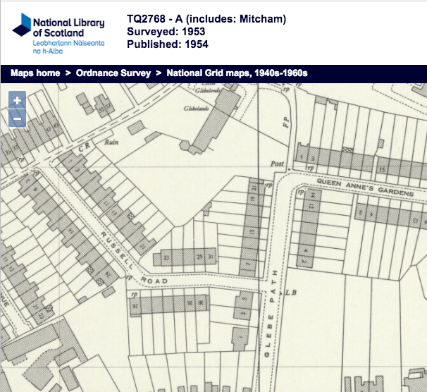
1953 OS map

The Glebe Path end of this road was originally called Bounty Place, presumably a reference to Queen Anne’s Bounty. It was renamed to be an extension of Russell Road, and hence renumbered, by Mitcham Urban District Council in 1930. Source: Mitcham UDC minutes, 24th June, 1930, page 171.


Maps are reproduced with the permission of the National Library of Scotland.

Blake Road

Road off Miles Road that leads to Collingwood and Rodney Roads. Built in 1930, by Mr J. Sands.

According to minutes of the Mitcham Urban Council, the original name suggested for this road was Felix Road, and that for Collingwood Road was San Road. The council suggested to Mr Sands the current names. Source: page 813, volume XV, Highways and Buildings Committee, 6th March 1930.

No houses were built on Blake Road. However it does have a block of four flats, numbered 1 to 4, at 30 Blake Road, CR4 3FB. This is a block between the Lloyds Pharmacy, at 75 to 79 Miles Road, and the terrace of houses in that end at number 69. The ground floor of this block facing Miles Road is number 71 in that road, occupied by a carpet and upholstery cleaning business. The entrance to the flats is in Blake Road.

1953 OS map


Minutes of meetings held by the Mitcham Urban District Council are available on request from the Merton Heritage and Local Studies Centre at Morden Library.

Maps are reproduced with the permission of the National Library of Scotland.