Author Archives: Wade

Gunsite

An area of Mitcham Common that is south of the Mitcham Junction tramstop and railway station, east of the Carshalton Road, and is bounded on its eastern edge by the railway line between Mitcham Junction and Hackbridge stations, and on its southern edge by the scaffolding yards at the rear of the Corporation Cottages.

The area is called the Gunsite after its use during WW2 as an anti-aircraft installation, as shown on this 1955 OS map:

1955 OS map

This photo shows what remained of the site around 1961. The view is towards the west and the houses of Carshalton Road can be seen in the background.

c.1961 photo of the Gun site, where children often played. From Merton Memories, photo reference Mitcham_War_5-2

Photo taken around 1961 of the Gunsite. The houses in the background are on Carshalton Road. Clip from Merton Memories, photo reference Mitcham_War_5-1

The Gunsite was demolished in 1962/3.

Mitcham News & Mercury, 13th July 1962.

At last
—Gunsite
is to go

ONE of Mitcham’s biggest eye-sores, the Gun Site, Carshalton Road, Mitcham, is at last going to be cleared . . . at a cost of about £13,000.

Work on clearing the site is expected to start in about two months’ time.
The Ministry have approved a tender of £10,800 submitted to them from the Conservators and have further agreed to bear the cost of replacing trees on the site.

WELCOMED

A further cost of £2,000 fees will be included in the work.

This news is welcomed not only by Mitcham Common Conservators but by Mitcham Council and the public.

The Gun Site is one of the few remaining war relics in Mitcham and local people have been pressing for years to clear it.

The conservators hope to replace it with a grass landscape with trees.

Demolition of buildings on the Gunsite, around 1962/3. In the background can be seen a signal at Mitcham Junction Railway Station, and part of the Mitcham Golf Club building. Clip from Merton Memories, photo reference Mitcham_War_5-3

Currently, the area shows no sign of its wartime use.

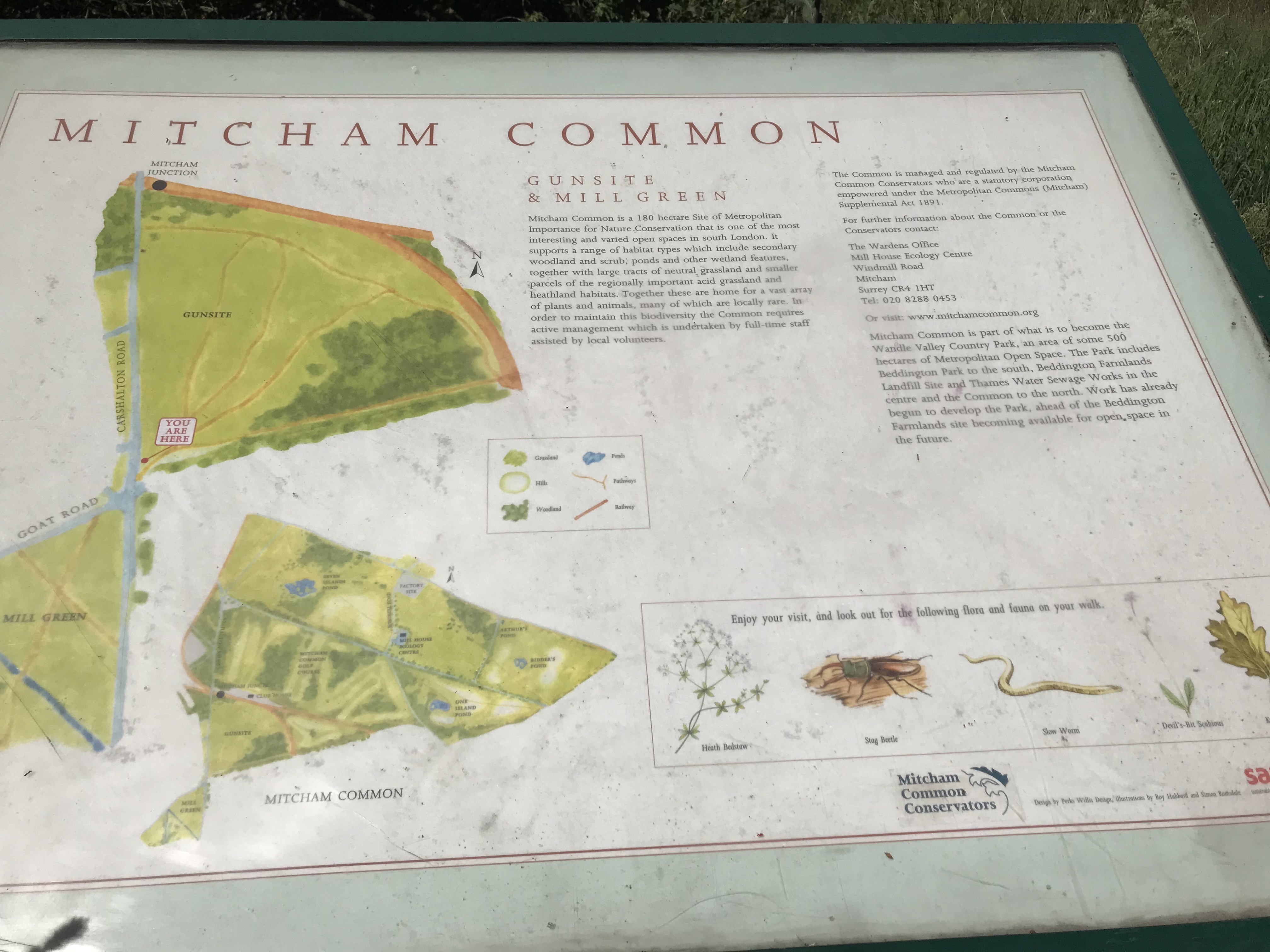
Information Board at the southern entrance to the Gunsite. Photo taken 22nd May 2020.

This board has no date and doesn’t mention the WW2 use of the area, however on the Conservator’s website, suggested walk no. 2, ‘Between The Tramstops’ (pdf) says:

… the area is known as the Gunsite because six anti-aircraft guns were stationed here during the second world war. The troop quarters were still present in the mid-1950s when they were used to house local people while new estates were being built in Mitcham.

The text on the info board:

Mitcham Common is a 180 hectare site of Metropolitan Importance for nature conservation that is one of the most interesting and varied open spaces in south London. It supports a range of habitat types which include secondary woodland and scrub, ponds and other wetland features, together with large tracks of natural grassland and smaller parcels of the regionally important acid grassland and heathland habitats. Together these are home for a vast array of plants and animals many of which are locally rare. In order to maintain this biodiversity the Common requires active management which is undertaken by full-time staff assisted by local volunteers.

The Common is managed and regulated by the Mitcham Common Conservators who are a statutory corporation empowered under the Metropolitan Commons (Mitcham) Supplemental Act 1891.

For further information about the common or the conservators contact :

The Wardens Office
Mill House Ecology Centre
Windmill Road
Mitcham
Surrey CR4 1HT
Tel: 020 8288 0453

Or visit: www.mitchamcommon.org

Mitcham Common is part of what is to become the Wandle Valley Country Park, and area of some 500 hectares of Metropolitan Open Space. the Park includes Beddington Park to the south, Beddington Farmlands landfill site and Thames Water Sewage Worksin the centre and the Common to the north. Work has already begun to develop the Park, ahead of the Beddington Farmlands site becoming available for open space in the future.

Note that the Metropolitan Commons (Mitcham) Supplemental Act 1891 is available to view on the Parliamentary Archives website.

News Items

Norwood News – Friday 06 January 1956

Gun-site families to change huts

The regrouping of families living at the gun site in Carshalton-road, near Mitcham Junction, will cost £1,000. The War Office, who want to clear up part of the site, have asked that the families should move into huts on the north side of the entrance road to the site. The condition of the huts the, people will move into is poor, say Mitcham Council. It is the conversion of the huts which will cost the money. Mitcham have agreed to the proposal on condition that the Ministry of Housing pay the cost of conversion.

Memories

Discussion on the Facebook Mitcham History Group led to these memories being recalled:

Carole said

… dad used to talk about the house opposite that had had its roof damaged and repaired so many times that they had V for victory in morse code in the tiles on the roof. Sadly, it was removed when re-roofed.

Eddie said

Happy memories as a kid playing there.

Isabella said

I was born on the gun site in 1947, lived there until 1954. I had a fantastic childhood growing up there.

Pat said

My brothers used to play there.

One night the whole of Pollards was out till 9pm looking for one of them ( he’d got carried away playing & forgot the time).

Another time my mum was cleaning under his bed & found a tin with hand grenades & bullets in it….she went with him to the police station and they had to have them blown up by the army. To say we’re lucky to be alive, is an understatement.

Terence said

I was born there in the old mess hut

Photos

Photo taken from a bench near the centre of the Gunsite area, looking west towards the Carshalton Road. Photo taken 18th May 2020.

One of the oak trees in the wooded area at the south eastern corner of the Gunsite. Photo taken 18th May 2020.


Maps are reproduced with the permission of the National Library of Scotland.

Love Lane

Following the road as it is currently numbered, it starts as a footpath off Church Road along the eastern side of the parish churchyard, and continues to Western Road.

1954 OS map showing the start of Love Lane at Church Road

Eric Montague, in his book, 12 Church Street and Whitford Lane, chapter 6, said that Love Lane almost certainly dated back to the Middle Ages as it served as the access lane to strips of land that stretched north of it. These strips were around a furlong, or 22 yards, in length, and the layouts of roads such as Frimley Gardens and Rodney Road to Fox’s Path, another access lane.

Entrance to Love Lane from Church Road. Photo taken when four 3-bed houses were being built on this corner by the Beaver Housing Society in 1996/7, which is now numbered as 82A Church Road.

In Love Lane, the houses with even numbers 2, 4 and 6 are on the right in the first part of the footpath, then 8, 10 and 12 are round the corner as the path heads east.

Then there is a block of four houses numbered 14, 16, 18 and 20, that have a datestone identifying it as Laburnum Cottages.

LABURNUM COTTAGES W. F. 1853

This block can be seen on this 1866 OS map:

1866 OS map

After this block the footpath ends, and on the left is a terrace of 6 houses, numbered 1 to 11. This has a name plate in the middle, partially obscured by a drainpipe, which says ‘Hope Terrace’.

Opposite this terrace are houses built around 1983, as planning permission MER170/83 was granted on 21st April 1983. They are numbered with suffixes.

Next to these houses on the right side of Love Lane is a three storey block of 12 flats called Frimley House, which has numbers 22 to 44. Possibly built late 1930s or post-WW2 as the block is not shown on the 1933 OS map.

Opposite Frimley House, and past Hope Terrace, are two pairs of semi-detached houses, numbers 11A and 15, 17 and 19. Next to 19 is number 21, a detached house that is on the corner with Frimley Gardens.

After this the roadway turns right into Church Place but Love Lane continues as a footpath until Edmund Road. On the right can be seen the remains of the entrance to the council depot.

Breeze block filling where entrance to depot was. Photo taken 20th April 2016.

Past Harwood Avenue, the next houses on Love Lane are a pair of semi-detached on the left numbered 23 (Hope Cottage) and 25 (Rose Cottage). This is the only remaining pair of such cottages from those that were built in the early 19th century. The 1896 street directory describes walking from Church Street to Western Road, i.e. in a easterly direction, and the occupants were:

Samuel BEALES (Hope Cottage)
John HUSSEY (Rose Cottage)

23 and 25 Love Lane. Photo taken 21st May 2020

Rose Cottage was the childhood home of William Henry SLATER, who emigrated to Australia in the late 1850s where he was one of the founders of the Mitcham township, now a suburb of Melbourne, Victoria.

This is followed by a terrace of 12 houses, numbered 27 to 49, which has the nameplate in the middle of ‘Douglas Cottages’. These were built in the first decade of the 20th century according to Montague., and were numbered 1 through 12, from west to east. In the 1915 directory Stewart Daniel SLATER, florist, is listed at no. 12.

1954 OS map

After Douglas Cottages is currently a nursery school, built in the early 1960s after a pair of semi-detached cottages, numbered 55 and 57, called Dent’s Cottages, was demolished. The Mitcham News & Mercury had an article in the 2nd September 1960 issue: 132-year old Love Lane cottage to come down.

Further along on the left hand side, after Dearn Gardens, are two detached houses that are set back from the road side at an angle, number 75 and number 77, the latter of which may have been called Glendene when it was occupied by George Victor DEARN, who developed Dearn Gardens.

75 Love Lane with its arched chimney stacks. Photo taken 21st May 2020

Next is a 3-storey block of 6 flats, numbered 79, 81, 83 and 79a, 81a, 83a. After which is a block of 2 houses, 85 and 87, with a third added on, number 89.

Corner of Love Lane and Taffy’s How shows no. 85, 87 and 89 Love Lane. Photo taken 15th July 2020

Houses numbers 103 to 121 were built in 1934 as part of the Pear Tree Close estate.

An older terrace of 4 houses, numbered 123 to 129, north of the corner with Westfield Road, dated from the 1880s, as are the similar houses on the north side of Westfield Road, according to Montague. The 1910-1911 street directory lists these houses as Knapdale Villas, with these occupants:

1, Frederick NEWSOM
2, Thomas ARTHUR
3, John HINCKLEY

A photo from around 1970 on Merton Memories, incorrectly labelled as Gladstone Road, shows these houses with their original slate roofs.

From Merton Memories, photo reference Mit_Streets_D_LEW_29-2

From the current footpath that leads to the Glebe Path and Queen Anne’s Gardens, on the right hand side of Love Lane northwards, were 6 pairs of semi-detached houses, five of which can be seen in this aerial photo from 1937.

1937 aerial photo from Britain From Above. Love Lane is on the right. Detached houses from right to left shown are numbers 100/102, 104/106, 108/110, 112/114, and 116/118.

No. 104/5. Clip of photo taken by Eric Montague in 1966. Reproduced by kind permission of the Merton Historical Society. Image reference mhs-em-wl-cr-9

Numbers 100/102 aren’t shown on this 1954 OS map, so may have been destroyed in the war. All six were demolished by the end of the 20th century and replaced by houses and bungalows.

1953 OS map reproduced by permission of the National Library of Scotland. Reuse CC-BY.

This 1910 OS map shows all 6 of the semi-detached houses.

1910 OS map

In the 1925 street directory, these houses were numbered from the Western Road end, from 1 sequentially to 12.

1, William John UPTON
2, John BICKNELL

3, John CARRETT
4, George William SLATER

5, Samuel Henry BATEMAN
6, Arthur Goodwin FUNNELL

7, Mrs GEORGE
8, Henry James STEERS

9, Hoseph George WHITE
10, Henry DEARN

11, Hames Joseph GRACE
12, Leonard George FORTNAM

In the 1898 street directory, no. 6 was also known as Ivy Cottage and no. 7 as Jasmine Cottage.


Maps are reproduced with the permission of the National Library of Scotland.