A chapel that was in Western Road, the site of the present Lidl store.

1978 Image courtesy of Collage – The London Picture Library – http://collage.cityoflondon.gov.uk

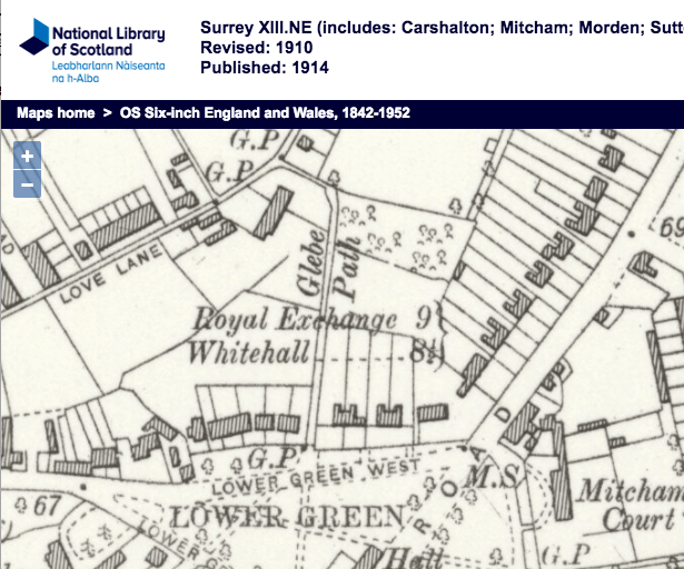
1910 OS map shows ‘Chap.’ (chapel) and ‘Sch.’ (school). The site is occupied by Lidl (in 2017).
The chapel and a Sunday school next to it was built in 1819. It was deconsecrated in 1930 and sold off and used by light industrial companies. Around 80 bodies were reburied in the new London Road cemetery.
The building was demolished in the late 1980s.
Source: Mitcham Histories : 14 Upper Mitcham and Western Road, by Eric Montague, chapter 9 ‘Zion Chapel’.
From the Mitcham Advertiser of 1st May 1914 :
One of the old landmarks is Zion Congregational Church, which this week celebrated its 95th anniversary with a series of successful gatherings. For close on a century good useful work has been carried on, and the church has a record for long service. It used to be known simply as Zion Church, one of the real old Independent churches. The Rev. R. Richman, the present minister, has served in that capacity for 34 years, more than one third of the church’s existence.
Mr Richman is a well known and highly respected figure in Mitcham. His work has not been confined to the church alone, for he has always taken a keen interest in the local government, and he has served on the Parish Council. He is still a member of the school managers, and in that direction does good work. In his church he is surrounded by body of zealous workers, many of whom have been engaged there for a long period of years, in fact one at least can boast of a longer record than the pastor himself, and that is Mr Gardener, the secretary of the Sunday school, who has held that post for 39 years.
This has been quite a week of presentations in Mitcham. On Monday night a presentation was made to Mr A. Gardener at Zion church in recognition of his 25 years service as a deacon. He is also Superintendent of the Sunday school. The name of Gardener has been associated with Zion Church for years. Mr Gardener’s mother was a descendant of the Huguenots. Yet another presentation at Zion Church was to Mr Simmons, another deacon, who has also been treasurer of the church, this week celebrated his silver wedding, he having been married at Zion Chapel 25 years ago.
For more details of the early vicars, see the ‘Mitcham entry in the Story of Congregationalism in Surrey‘.
Married at the old Zion chapel on 13th January 1883, was Mr and Mrs Robinson Henery AMBROSE, who celebrated their golden anniversary at the Mitcham Garden Village on 13th January, 1933, according to the Mitcham News & Mercury of that date. They were active members of the Salvation Army.
Maps are reproduced with the permission of the National Library of Scotland.