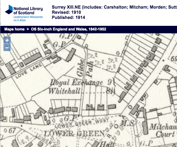
Farm house and land off west side of Carshalton Road, on part of what is now the Willow Lane industrial estate. Also known as Rumbold’s Farm or Rumbold Castle, it dated back to the 17th century.

1867 OS map
As reported in the London Evening Standard – Saturday 16 February 1861, the Great Ormond Street Hospital, which had been established in 1852, used its Samaritan Fund to obtain for convalescing children
the renovating influence of sea and country air, and in a large measure the committee were indebted for the opportunity of doing this to the kindness of two friends of the charity, one of whom, at Brighton, undertakes the entire cost of the Home which she has established there, whilst Lady Harding receives the children at a moderate charge of Rumbold’s Farm, Mitcham, a home founded by and still under her management.
The archivists at Great Ormond Street Hospital said that from 1869, the Hospital for Sick Children had its own convalescent home at Cromwell house in Highgate, but prior to that, after opening in 1852, they used the Mitcham home run by Lady Harding and another private home in Brighton. From 1927-83 the hospital had a larger ‘Country Branch’ further out in Surrey at Tadworth Court, which continues to operate today as a charitable trust providing respite care services for children.
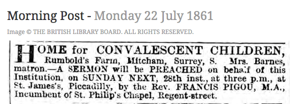
Morning Post – Monday 22 July 1861 via British Newspaper Archive
The 1881 census shows a Rumbolt Boarding School, listed between Flat Tops and the Mitcham Junction Railway station. The census lists 46 pupils at the school, with ages from 3 to 12.
Who had the right spelling? The OS maps show Rumbold and the census as Rumbolt.
The farm went up for sale in 1885:
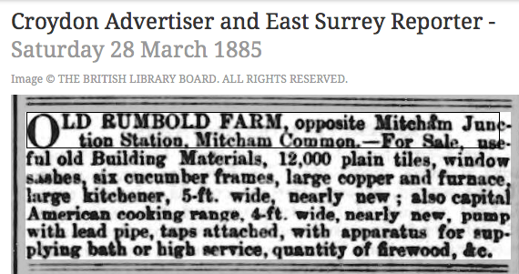
Croydon Advertiser and East Surrey Reporter – Saturday 28 March 1885 – via British Newspaper Archive
Text of ad:
OLD RUMBOLD FARM, opposite Mitcham Junction Station. Mitcham Common.—For Sale, useful old Building Materials, 12,000 plain tiles, window sashes. six cucumber frames, large copper and furnace, large kitchener, 5-ft. wide, nearly new; also capital American cooking range. 4-ft. wide, nearly new, pump with lead pipe, taps attached, with apparatus for supplying bath or high service, quantity of firewood, &c.
Tom Francis took a photo of the farmhouse, which can be seen on Merton Memories.
Maps are reproduced with the permission of the National Library of Scotland.